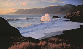
King Range (California)
| King Range | |
|---|---|

Beach & surf, King Range National Conservation Area
|
|
| Highest point | |
| Peak | King Peak |
| Elevation | 4,091 ft (1,247 m) |
| Coordinates | 40°09′25″N 124°07′27″W / 40.15694°N 124.12417°W |
| Geography | |
| Country | United States |
| State | California |
| County | Humboldt County |
| Range coordinates | 40°09′54.506″N 124°08′3.141″W / 40.16514056°N 124.13420583°WCoordinates: 40°09′54.506″N 124°08′3.141″W / 40.16514056°N 124.13420583°W |
| Topo map | USGS Shubrick Peak |
The King Range is a mountain range of the Outer Northern California Coast Ranges System, located entirely within Humboldt County on the North Coast of California.
Much of the mountain range's area is protected within the King Range National Conservation Area, a National Conservation Area unit of the National Landscape Conservation System, and in the King Range Wilderness Area, both managed by the Bureau of Land Management (BLM).
As part of the Northern Coast Ranges, the King Range runs parallel to the coast, and its western slopes fall steeply to the Pacific Ocean.
The King Range is adjacent to the Mendocino Triple Junction, where three tectonic plates — the Pacific Plate, the North American Plate, and the Juan de Fuca Plate — meet. The area experiences frequent earthquakes.
Most mountains and ridges in the range are low to moderate in elevation. King Peak, at 4,091 feet (1,247 m), is the highest mountain in the range. Snow falls above 3,281 feet (1,000 m) a couple of times per year.
The range is part of the Northern California coastal forests ecoregion. It is largely forested with climax-dominant trees including coast Douglas-fir (Pseudotsuga menziesii ssp. menziesii), coast redwood (Sequoia sempervirens), and tanoak (Lithocarpus densiflorus).
...
Wikipedia


