Whitethorn, California
| Whitethorn, California | |
|---|---|
| Unincorporated community | |
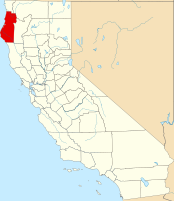
 Location in the state of California |
|
| Location in the United States | |
| Coordinates: 40°01′26″N 123°56′35″W / 40.02389°N 123.94306°W | |
| Country | United States |
| State | California |
| County | Humboldt County |
| Elevation | 1,024 ft (312 m) |
Coordinates: 40°01′26″N 123°56′35″W / 40.02389°N 123.94306°W
Whitethorn (formerly, Thorn) is an unincorporated community in Humboldt County, California. It is located 9.5 miles (15 km) southwest of Garberville, at an elevation of 1024 feet (312 m), population 817. Whitethorn shares a zip code with Shelter Cove, California. It is located along California's Lost Coast. The ZIP Code is 95589.
The Thorn post office opened in 1888, closed in 1923, reopened in 1951, and changed its name to Whitethorn in 1961. The Whitethorn post office is located near Thorn Junction on the road between Shelter Cove and Whitethorn. Some remote areas in northern Mendocino County are also served by this post office and thus have Whitethorn addresses.
Whitethorn Elementary School (grades K-7) is located in Whitethorn and is part of the Southern Humboldt Unified School District. Students from the Whitethorn area attend South Fork High School in Miranda.
Whale Gulch Elementary (grades K-8) and Whale Gulch High School are about 3 miles (5 km) southeast from Whitethorn. They have Whitethorn addresses, but are located in Mendocino County and are part of the Leggett Valley Unified School District.
About 1.5 miles (2.5 km) south of central Whitethorn is Redwoods Monastery, a community of Cistercian nuns.
...
Wikipedia

