Mattawa River
| Mattawa River | |
| Petite Rivière | |
|
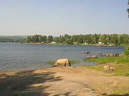
Pimisi Lake on the Mattawa River.
|
|
| Name origin: Algonquin language | |
| Country | Canada |
|---|---|
| State | Ontario |
| District | Nipissing District |
| Tributaries | |
| - right | Kaibuskong River Amable du Fond River |
| Source | Trout Lake |
| - location | North Bay, Ontario |
| - elevation | 198.5 m (651 ft) |
| - coordinates | 46°18′48″N 79°16′09″W / 46.31333°N 79.26917°W |
| Mouth | Ottawa River |
| - location | Mattawa, Ontario |
| - elevation | 148 m (486 ft) |
| - coordinates | 46°19′13″N 78°42′26″W / 46.32028°N 78.70722°WCoordinates: 46°19′13″N 78°42′26″W / 46.32028°N 78.70722°W |
| Length | 76 km (47 mi) |
| Basin | 1,170 km2 (452 sq mi) |
| Mattawa River Provincial Park | |
|---|---|
|
IUCN category II (national park)
|
|
| Location | Ontario, Canada |
| Nearest city |
North Bay Mattawa |
| Area | 32.57 km2 (12.58 sq mi) |
| Established | 1970 |
| Governing body | Ontario Parks |
The Mattawa River is a river in central Ontario, Canada. It flows east from Trout Lake east of North Bay and enters the Ottawa River at the town of Mattawa. Counting from the head of Trout Lake, it is 76 km in length. The river's name comes from the Algonquin word for "meeting of waterways".
Two provincial parks are located along it: the Mattawa River Waterway Provincial Park stretches along both sides of the river's banks for almost its full length; and Samuel de Champlain Provincial Park, located about 10 km from the river's end.
The river follows inside an ancient fault line through the Algoma Highlands called the Mattawa Fault. This fault line marks the northern edge of an ancient rift valley, called the Ottawa-Bonnechere Graben, and still causes minor earthquakes in the area. From Lake Talon to Mattawa the river flows through a rock-walled canyon up to 150 metres (490 ft) in places.
Tributaries include the:
An interesting feature is the Porte de l'Enfer (Hell's Gate). This is a peculiar cave in the river's bank speculated to be a native ochre mine. As far back as 1761, Alexander Henry the elder reported on this cave and the myths surrounding it. It was said to be inhabited by an evil and fierce demon, hence its name.
Evidence of a post-glacial spillway which drained the Great Lakes into the Ottawa River until about 4000 years ago can be seen at several sites along the river. There are potholes at Portage de Talon and numerous cataracts and former river channels, such as the boulder pavement between Pine Lake and McCool Bay, 12–15 metres (39–49 ft) above the river's present day water-line.
...
Wikipedia

