Matsuzaka, Mie
|
Matsusaka 松阪市 |
|||
|---|---|---|---|
| City | |||

Traditional street in central Matsusaka
|
|||
|
|||
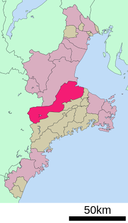
 Location of Matsusaka in Mie Prefecture |
|||
| Coordinates: 34°34′40.6″N 136°31′39.3″E / 34.577944°N 136.527583°ECoordinates: 34°34′40.6″N 136°31′39.3″E / 34.577944°N 136.527583°E | |||
| Country | Japan | ||
| Region | Kansai, Tōkai | ||
| Prefecture | Mie Prefecture | ||
| Government | |||
| • Mayor | Mitsushige Yamanaka | ||
| Area | |||
| • Total | 623.64 km2 (240.79 sq mi) | ||
| Population (August 2015) | |||
| • Total | 165,166 | ||
| • Density | 265/km2 (690/sq mi) | ||
| Time zone | Japan Standard Time (UTC+9) | ||
| Symbols | |||
| • Tree | Pine | ||
| • Flower | Lilium auratum | ||
| • Bird | Japanese bush-warbler | ||
| Phone number | 0598-53-4311 | ||
| Address | 1340-1 Tonomachi, Matsusaka-shi, Mie-ken 515-8515 | ||
| Website | www |
||
Matsusaka (松阪市 Matsusaka-shi?) is a city located in Mie Prefecture, Japan.
As of August 2015, the city had an estimated population of 165,166 and a population density of 265 persons per km2. The total area was 623.64 square kilometres (240.79 sq mi). The city is famous for Matsusaka beef.
Matsusaka is located in east-central Kii Peninsula, in central Mie Prefecture. It stretches the width of Mie Prefecture, and is bordered by Ise Bay on the Pacific Ocean to the east, and Nara Prefecture to the west. Parts of the City are within the limits of the Yoshino-Kumano National Park.
Matsusaka developed as a commercial center during the Sengoku period, and Oda Nobukatsu, the younger son of Oda Nobunaga built a castle in the area in 1580. The area came under the control of Gamo Ujisato shortly thereafter, and the Gamo began construction of a castle in the Yoiho forest (四五百森 Yoiho no mori?) and named the site "Matsusaka," meaning "slope (坂) covered with pines (松)" in 1588.
...
Wikipedia


