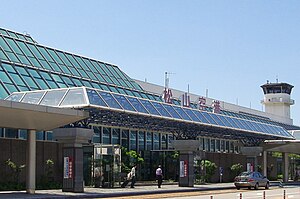
Matsuyama Airport
|
Matsuyama Airport 松山空港 Matsuyama kūkō |
|||||||||||
|---|---|---|---|---|---|---|---|---|---|---|---|
 |
|||||||||||
| Summary | |||||||||||
| Airport type | Public | ||||||||||
| Operator | Ministry of Land, Infrastructure, Transport and Tourism | ||||||||||
| Serves | Matsuyama | ||||||||||
| Elevation AMSL | 13 ft / 4 m | ||||||||||
| Coordinates | 33°49′38″N 132°41′59″E / 33.82722°N 132.69972°ECoordinates: 33°49′38″N 132°41′59″E / 33.82722°N 132.69972°E | ||||||||||
| Website | www.matsuyama-airport.co.jp | ||||||||||
| Map | |||||||||||
| Location in Japan | |||||||||||
| Runways | |||||||||||
|
|||||||||||
| Statistics (2015) | |||||||||||
|
|||||||||||
|
Source: Japanese Ministry of Land, Infrastructure, Transport and Tourism
|
|||||||||||
| Passengers | 2,863,239 |
|---|---|
| Cargo (metric tonnes) | 7,696 |
| Aircraft movement | 30,987 |
Matsuyama Airport (松山空港 Matsuyama kūkō?) (IATA: MYJ, ICAO: RJOM) is an airport located 3 NM (5.6 km; 3.5 mi) west southwest of Matsuyama, Ehime, Japan.
The airport opened as an Imperial Japanese Navy (Nihon kaigun) airfield in 1941.At the end of the war IT was the base of the 353th fighter squadron which défend Japan against saipan B-29 's raids and became a state-administre civil airport in 1958. It was the first airport in Shikoku to see jet service following a runway extension project in 1972.
An office park named "Biz Port" opened near the airport in 2003 to attract technology businesses, but is scheduled to close on 1 April 2015.
In 2013, the government of Ehime Prefecture and local business organizations announced that they would begin subsidizing the airport's international routes to Shanghai and Seoul, which had seen load factors of less than 50% in June 2013.
...
Wikipedia

