Matfield Green, Kansas
| Matfield Green, Kansas | |
|---|---|
| City | |
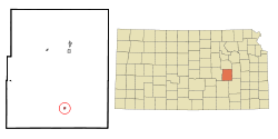
 Location within Chase County and Kansas |
|
 KDOT map of Chase County (legend) |
|
| Coordinates: 38°9′35″N 96°33′43″W / 38.15972°N 96.56194°WCoordinates: 38°9′35″N 96°33′43″W / 38.15972°N 96.56194°W | |
| Country | United States |
| State | Kansas |
| County | Chase |
| Township | Matfield |
| Government | |
| • Type | Mayor–Council |
| Area | |
| • Total | 0.14 sq mi (0.36 km2) |
| • Land | 0.14 sq mi (0.36 km2) |
| • Water | 0 sq mi (0 km2) |
| Elevation | 1,316 ft (401 m) |
| Population (2010) | |
| • Total | 47 |
| • Estimate (2015) | 45 |
| • Density | 340/sq mi (130/km2) |
| Time zone | Central (CST) (UTC-6) |
| • Summer (DST) | CDT (UTC-5) |
| ZIP code | 66862 |
| Area code | 620 |
| FIPS code | 20-45150 |
| GNIS feature ID | 0477807 |
Matfield Green is a city in Chase County, Kansas, United States. As of the 2010 census, the city population was 47.
For many millennia, the Great Plains of North America was inhabited by nomadic Native Americans. The historic Native American tribes of Kansas are many, including the Kansa, or "Wind People," from whom the name of the state is derived. Also included are the related Osage, Pawnee, and Wichita. From the west and north ranged the Comanche and Apache, as well as the Kiowa, Cheyenne and Arapaho.
From the 16th century to 18th century, the Kingdom of France claimed ownership of large parts of North America. In 1762, after the French and Indian War, France secretly ceded New France to Spain, per the Treaty of Fontainebleau.
In 1802, Spain returned most of the land to France. In 1803, most of the land for modern day Kansas was acquired by the United States from France as part of the 828,000 square mile Louisiana Purchase for 2.83 cents per acre.
...
Wikipedia
