Masroor Rock Cut Temple
|
Masroor Rock Cut Temple Masrur Temple, Kangra Valley, Himachal Pradesh, India |
|
|---|---|

Masroor Rock Cut Temple reflected in the pool of water
|
|
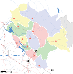
| Location in Himachal Pradesh, India | |
| Coordinates: 30°30′21″N 76°9′4″E / 30.50583°N 76.15111°ECoordinates: 30°30′21″N 76°9′4″E / 30.50583°N 76.15111°E | |
| Country |
|
| State | Himachal Pradesh |
| District | Kangra |
| Built | 8th century CE |
| Elevation | 733 m (2,405 ft) |
| Languages | |
| • Official | Hindi |
| Time zone | IST (UTC+5:30) |
| Vehicle registration | HP |
The Masroor Rock Cut Temple or Himalayan Pyramid is a complex of temples located in Masroor (or Masrur) in Kangra Valley, which is 40 kilometres (25 mi) from Kangra city in Kangra district of the Indian state of Himachal Pradesh. It is now known as 'Thakurwada', meaning "Vaishnavite temples". It is a complex of monolithic rock cut temples, in shikhara (raising tower) style of classical Indian architectural style, dated by art historians to 6–8th centuries. Such an architectural style is unique to the northern part of India while there are many places in western and southern India where such rock-cut structures exist at number of locations. There is a lake or pond called Masroor lake in front of this edifice which shows partial reflection of the temples. A legend attributes its construction to the Pandavas of Mahabharata fame who resided here during their "incognito" exile (Ajnatavasa) from their kingdom.
The temple complex is on a rocky ridge over which an array of monolithic (made of a single block of stone) temples have been carved which resemble the monolithic temples of Mahabalipuram, Ellora and Dhamnar caves. The central temple of this complex, called the Thakurdwara, has extensive well crafted carvings. This shrine facing east has idols of Ram, Lakshman and Sita (made of black-stone).
The Masroor Rock Cut Temple, also known as Himalayan Pyramid, is a complex of temples located in the rolling topography of the Kangra Valley in the Dehra Gopipur tehsil, in the backdrop of the Dhauladar Range and Beas River valley with geographical coordinates of 30°00′N 76°10′E / 30.00°N 76.16°E. It is located at the highest point of a local hill feature. It is close to Dharmashala, which is about 35 kilometres (22 mi) away. The temple complex is approachable now from a new 2-kilometre (1.2 mi) road built from Pir Bindli near Lunj. There is also a lake or pond called Masroor lake in front of this edifice which shows partial reflection of the temples.
...
Wikipedia


