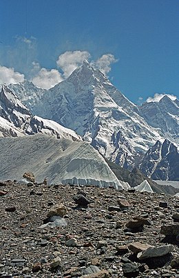
Masherbrum
| Masherbrum | |
|---|---|
| K1 | |

Masherbrum, July 2004
|
|
| Highest point | |
| Elevation | 7,821 m (25,659 ft) Ranked 22nd |
| Prominence | 2,457 m (8,061 ft) |
| Listing | Ultra |
| Coordinates | 35°38′24″N 76°18′21″E / 35.64000°N 76.30583°ECoordinates: 35°38′24″N 76°18′21″E / 35.64000°N 76.30583°E |
| Geography | |
| Location | Ghanche District, Gilgit Baltistan, Pakistan |
| Parent range | Karakoram |
| Climbing | |
| First ascent | 1960 by George Bell and Willi Unsoeld |
| Easiest route | glacier/snow/ice climb |
Masherbrum (formerly known as K1) is located in the Ghanche District, Gilgit Baltistan of Pakistan. At 7,821 metres (25,659 ft) it is the 22nd highest mountain in the world and the 9th highest in Pakistan. It was the first mapped peak in the Karakoram mountain range, hence the designation "K1".
Although "brum" means mountain in Balti, the origin of "masher" is less clear. Some have suggested that it derives from "Mashedar", meaning a muzzle-loader, due to the characteristic curvature of its summit as viewed from Baltoro Glacier. In Persian, "masheh" means both matchlock and trigger, and "dar" is a suffix meaning "having". Others have noted that "Masha" means lady, and "Masherbrum" is the "Queen of Peaks". Still others have noted that "Masher" means "no sunlight", in reference to the year-round snow cover at the summit.
Masherbrum is the highest peak of the Masherbrum Mountains, a subrange of the Karakoram range. It is a large and striking peak, which is somewhat overshadowed by the nearby 8,000 metres (26,000 ft) peaks of the main range of the Karakoram which includes four of the fourteen Eight-thousanders, namely K2, Gasherbrum I, Broad Peak and Gasherbrum II.
The Masherbrum Mountains lie to the south of the Baltoro Glacier and the main range of the Karakoram lies to the north of the Baltoro. The main range is the continental divide of southern Asia. Rivers to the south flow into the Arabian Sea. Rivers to the north flow into the Tarim Basin.
...
Wikipedia

