Gasherbrum II
| Gasherbrum II | |
|---|---|
| K4 | |

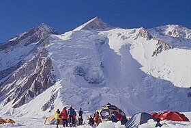
Gasherbrum II from Base Camp
|
|
| Highest point | |
| Elevation | 8,035 m (26,362 ft) Ranked 13th |
| Prominence | 1,524 m (5,000 ft) |
| Isolation | 5.26 kilometres (3.27 mi) |
| Listing |
Eight-thousander Ultra |
| Coordinates | 35°45′30″N 76°39′12″E / 35.75833°N 76.65333°ECoordinates: 35°45′30″N 76°39′12″E / 35.75833°N 76.65333°E |
| Geography | |
| Location | Gilgit–Baltistan, Pakistan |
| Parent range | Karakoram |
| Climbing | |
| First ascent | July 7, 1956 by Fritz Moravec, Josef Larch and Hans Willenpart |
| Easiest route | Snow/ice climb |
Gasherbrum II (Urdu: گاشر برم -2; , also known as K4, is the 13th highest mountain in the world at 8,035 metres (26,362 ft) above sea level. It is the third-highest peak of the Gasherbrum massif, and is located in the Karakoram, on the border between Gilgit–Baltistan province, Pakistan, and Xinjiang, China. The mountain was first climbed on July 7, 1956, by an Austrian expedition which included Fritz Moravec, Josef Larch, and Hans Willenpart.
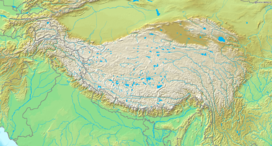
Gasherbrum II is located on the border of Gilgit–Baltistan, Pakistan, and Xinjiang, China. It is part of the Karakoram mountain range in the Himalayas, and located at the top of the Baltoro Glacier. With an elevation of 8,035 metres (26,362 ft) it is the third-highest member of the Gasherbrum group, behind Gasherbrum I (8,080 metres or 26,510 feet) and Broad Peak (8,051 metres or 26,414 feet).Gasherbrum III is sometimes considered to be a subpeak of Gasherbrum II, because the former has a topographic prominence of only 461 metres (1,512 ft).
In 1856, Thomas George Montgomerie, a member of the British Royal Engineers and part of the Great Trigonometric Survey, sighted the mountain and named it "K4", meaning the fourth mountain of Karakoram. The name "Gasherbrum" comes from the Balti words rgasha ("beautiful") and brum ("mountain"); it does not, contrary to popular belief, mean "shining wall", how Sir William Martin Conway described nearby Gasherbrum IV on an 1892 exploration.
...
Wikipedia

