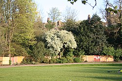
Maryon Park
| Maryon Park | |
|---|---|

Maryon Park, London
|
|
| Type | • Public park • Urban park |
| Location |
Charlton, Greenwich, London, England, United Kingdom |
| Coordinates | 51°29′20″N 0°02′35″E / 51.489°N 0.043°ECoordinates: 51°29′20″N 0°02′35″E / 51.489°N 0.043°E |
| Operated by | Greenwich London Borough Council |
| Status | Open year round |
| Website | "Marion Park" (descriptive page on Maryon Park at greenwich.gov.uk, the Greenwich London Borough Council's official website) |
Maryon Park is an urban public park located in Charlton in the Royal Borough of Greenwich. It is situated on the A206 south of the Thames Barrier. There is access from Woolwich Road, Charlton Lane and Thorntree Road. It is part of the Maryon Wilson Park and Gilbert's Pit Local Nature Reserve.
Charlton sandpits, which were originally part of an area known as Hanging Wood, were presented to the London County Council in 1891 by the Maryon-Wilson family, and one of the pits became Maryon Park. Another pit became Charlton Athletic's football ground, The Valley.
The park was originally wooded and, together with what is now Maryon Wilson Park, was known as Hanging Woods. This was a wild wooded area and formed an ideal retreat for highwaymen who robbed travellers on Shooters Hill and Blackheath. Those who were caught were hanged here – hence the name.
The park contains grassland, with hawkweed, gorse and broom.
The park includes Cox's Mount, which was used by the Romans as a hill fort, which was discovered in 1915. In the 1850s, Cox's Mount was used to help ships on the nearby River Thames adjust their compasses.
...
Wikipedia
