Maryland Route 51
| Maryland Route 51 | ||||
|---|---|---|---|---|

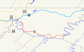
Maryland Route 51 highlighted in red
|
||||
| Route information | ||||
| Maintained by MDSHA | ||||
| Length: | 25.53 mi (41.09 km) | |||
| Existed: | 1927 – present | |||
| Tourist routes: |
|
|||
| Major junctions | ||||
| West end: |
|
|||
|
Canal Parkway in Cumberland |
||||
| East end: |
|
|||
| Location | ||||
| Counties: | Allegany | |||
| Highway system | ||||
|
||||
Canal Parkway in Cumberland
Maryland Route 51 (MD 51) is a state highway in the U.S. state of Maryland. Known for most of its length as Oldtown Road, the state highway runs 25.53 miles (41.09 km) from an interchange with Interstate 68 (I-68) in Cumberland east to the West Virginia state line at the Potomac River, where the highway continues east as West Virginia Route 9 (WV 9) toward Paw Paw. Around Cumberland, MD 51 is a major highway that provides a bypass of the South End neighborhood of that city and access to industrial areas along the Potomac River. East of North Branch, MD 51 is a rural highway connecting small communities along the river in southeastern Allegany County, including Oldtown.
The city streets of Cumberland on which MD 51 was later designated were paved by 1910. The highway was constructed from the city limits of Cumberland to North Branch in the mid-1920s and to Paw Paw in the early 1930s and dedicated as Uhl Highway. Industrial Boulevard, a divided highway in the city of Cumberland, was constructed in the mid-1960s. MD 51 between Evitts Creek and North Branch was relocated in the mid-1980s to better serve nearby industrial properties.
MD 51 begins at an intersection with ramps of I-68 Exit 43B. Mechanic Street heads north from the intersection toward the Downtown Cumberland Historic District, providing access to the western end of the Chesapeake and Ohio Canal National Historical Park (C&O Canal) at Canal Place. A ramp to eastbound I-68 forms the east leg of the intersection, while Howard Street, which receives a ramp from westbound I-68, is the west leg. MD 51 heads south as Industrial Boulevard, a two-lane divided highway. Just south of its terminus, the state highway intersects Winston Street and Queen City Drive and receives a ramp from eastbound I-68. Queen City Drive is used by MD 51 west to access Centre Street, which has a ramp to westbound I-68. South of I-68 and Queen City Drive, MD 51 becomes a six-lane divided highway for a very short distance before Canal Parkway, which is unsigned MD 61, exits eastbound and enters westbound just ahead of a bridge over CSX's Cumberland Terminal Subdivision.
...
Wikipedia

