Paw Paw, West Virginia
| Paw Paw | |
|---|---|
| Town | |

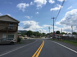
WV 9 in Paw Paw
|
|
 Location in Morgan County and the state of West Virginia. |
|
| Coordinates: 39°31′52″N 78°27′25″W / 39.53111°N 78.45694°WCoordinates: 39°31′52″N 78°27′25″W / 39.53111°N 78.45694°W | |
| Country | United States |
| State | West Virginia |
| County | Morgan |
| Area | |
| • Total | 0.53 sq mi (1.37 km2) |
| • Land | 0.53 sq mi (1.37 km2) |
| • Water | 0 sq mi (0 km2) |
| Elevation | 571 ft (174 m) |
| Population (2010) | |
| • Total | 508 |
| • Estimate (2012) | 500 |
| • Density | 958.5/sq mi (370.1/km2) |
| Time zone | Eastern (EST) (UTC-5) |
| • Summer (DST) | EDT (UTC-4) |
| ZIP code | 25434 |
| Area code(s) | 304 |
| FIPS code | 54-62332 |
| GNIS feature ID | 1544641 |
Paw Paw is a town in Morgan County, West Virginia, United States. The population was 508 at the 2010 census. The town is known for the nearby Paw Paw Tunnel. Paw Paw was incorporated by the Circuit Court of Morgan County on April 8, 1891 and named for the pawpaw, a wild fruit which grows in abundance throughout this region. Paw Paw is the westernmost incorporated community in the Hagerstown-Martinsburg, MD-WV Metropolitan Statistical Area.
Paw Paw is located at 39°31′52″N 78°27′25″W / 39.53111°N 78.45694°W (39.531140, -78.456920).
According to the United States Census Bureau, the town has a total area of 0.53 square miles (1.37 km2), all of it land.
As of the census of 2010, there were 508 people, 223 households, and 131 families residing in the town. The population density was 958.5 inhabitants per square mile (370.1/km2). There were 262 housing units at an average density of 494.3 per square mile (190.9/km2). The racial makeup of the town was 92.9% White, 2.4% African American, 2.0% Native American, 0.4% Asian, 0.4% from other races, and 2.0% from two or more races. Hispanic or Latino of any race were 2.6% of the population.
...
Wikipedia
