Martley
| Martley | |
|---|---|
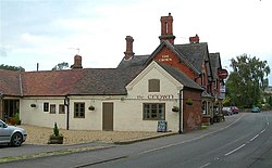
 The Crown |
|
| Martley shown within Worcestershire | |
| OS grid reference | SO754597 |
| Civil parish |
|
| District | |
| Shire county | |
| Region | |
| Country | England |
| Sovereign state | United Kingdom |
| Post town | WORCESTER |
| Postcode district | WR6 |
| Dialling code | 01886 |
| Police | West Mercia |
| Fire | Hereford and Worcester |
| Ambulance | West Midlands |
| EU Parliament | West Midlands |
| UK Parliament | |
Martley is a village and civil parish in the Malvern Hills district of the English county of Worcestershire. It is approximately nine miles north-west of Worcester. The population of the village is approximately 1,200 people. The mixed farming of the area includes arable, formerly cherry, apple, damson orchards and hopyards.
It is a popular village for retired people and professionals working in the city and surrounding towns, and has a large high school to which around 700 pupils are bussed daily from the surrounding area. It has a sports hall with rock climbing wall and a gym within the grounds of the school can be used by the public out of school times.
The village and its extensive parish sits astride the Malvern Line, a north-south aligned lineament originating in Precambrian times. To the east are Triassic sandstones whilst to the west are Devonian mudstones. Along the lineament itself are a complex mix of rocks of Precambrian, Cambrian and Silurian age.
Berrow Hill, an Iron Age hillfort, is one of several in the area, which hosts a beacon.
Martley was in the upper division of Doddingtree Hundred.
Following the Poor Law Amendment Act 1834 Martley Parish ceased to be responsible for maintaining the poor in its parish. This responsibility was transferred to Martley Poor Law Union.
...
Wikipedia

