Marlton, New Jersey
| Marlton, New Jersey | |
|---|---|
| Census-designated place | |

John Inskeep Homestead
|
|
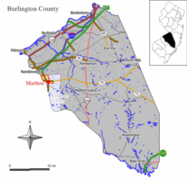
 Map of Marlton CDP in Burlington County. Inset: Location of Burlington County in the State of New Jersey. |
|
 Census Bureau map of Marlton, New Jersey |
|
| Coordinates: 39°54′07″N 74°55′45″W / 39.901885°N 74.929277°WCoordinates: 39°54′07″N 74°55′45″W / 39.901885°N 74.929277°W | |
| Country |
|
| State |
|
| County | Burlington |
| Township | Evesham |
| Area | |
| • Total | 3.235 sq mi (8.378 km2) |
| • Land | 3.227 sq mi (8.357 km2) |
| • Water | 0.008 sq mi (0.021 km2) 0.25% |
| Elevation | 95 ft (29 m) |
| Population (2010 Census) | |
| • Total | 10,133 |
| • Density | 3,140.3/sq mi (1,212.5/km2) |
| Time zone | Eastern (EST) (UTC-5) |
| • Summer (DST) | Eastern (EDT) (UTC-4) |
| ZIP code | 08053 |
| Area code(s) | 856 |
| FIPS code | 3444100 |
| GNIS feature ID | 02390126 |
Marlton is an unincorporated community and census-designated place (CDP) located within Evesham Township in New Jersey, United States. As of the 2010 United States Census, Marlton's population was 10,133.
Marlton was founded by Welsh and English farmers beginning in 1676. The name Marlton first appeared in the early 19th century. The name is derived from marl clay, which is commonly found in the local soil. The discovery of the marl content helped local business and farmers, and caused the first "building boom", occurring in the 1830s and 1840s. Marl continued to be excavated in Marlton until 1930, when the pits were shut down. The marl was sold locally, and shipped directly, by rail to Burlington City, Philadelphia, Pennsylvania, and Atlantic City, for reshipping as an alternate for green manure, water treatment amendment, and semi-flowable fill.
PH-32, a Project Nike missile base from the Cold War, was located near Cherokee High School.
According to the United States Census Bureau, Marlton had a total area of 3.235 square miles (8.378 km2), including 3.227 square miles (8.357 km2) of it is land and 0.008 square miles (0.021 km2) of water (0.25%).
The 2010 United States Census counted 10,133 people, 4,126 households, and 2,653 families residing in the CDP. The population density was 3,140.3 per square mile (1,212.5/km2). The CDP contained 4,343 housing units at an average density of 1,345.9 per square mile (519.7/km2). The racial makeup of the CDP was 86.57% (8,772) White, 4.27% (433) Black or African American, 0.15% (15) Native American, 6.10% (618) Asian, 0.01% (1) Pacific Islander, 1.30% (132) from other races, and 1.60% (162) from two or more races. Hispanics or Latinos of any race were 4.41% (447) of the population.
...
Wikipedia
