Marion County, Missouri
| Marion County, Missouri | |
|---|---|

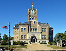
Marion County courthouse in Palmyra
|
|
 Location in the U.S. state of Missouri |
|
 Missouri's location in the U.S. |
|
| Founded | December 23, 1826 |
| Named for | Francis Marion |
| Seat | Palmyra |
| Largest city | Hannibal |
| Area | |
| • Total | 444 sq mi (1,150 km2) |
| • Land | 437 sq mi (1,132 km2) |
| • Water | 7.4 sq mi (19 km2), 1.7% |
| Population (est.) | |
| • (2015) | 28,880 |
| • Density | 66/sq mi (25/km²) |
| Congressional district | 6th |
| Time zone | Central: UTC-6/-5 |
| Website | http://marioncountymo.com/ |
| Marion County, Missouri | ||||
|---|---|---|---|---|
| Elected countywide officials | ||||
| Assessor | Mark Novak | Democratic | ||
| Circuit Clerk | Valerie Munzlinger (Division I) / Carolyn Conners (Division II) | Democratic | ||
| County Clerk | Valerie Dornberger | Democratic | ||
| Collector | Mary Ann Viorel | Democratic | ||
|
Commissioner (Presiding) |
Lyndon Bode | Democratic | ||
|
Commissioner (District 1) |
Robert Heiser | Democratic | ||
|
Commissioner (District 2) |
Randy Spratt | Republican | ||
| Coroner | Darrell McCoy | Democratic | ||
| Prosecuting Attorney | Thomas P. Redington | Democratic | ||
| Public Administrator | Wendy Howe | Democratic | ||
| Recorder | Janet Dearing | Democratic | ||
| Sheriff | Jimmy Shinn | Democratic | ||
| Surveyor | John D. Janes | Independent | ||
| Treasurer | Joelle Fohey | Democratic | ||
| Marion County, Missouri | ||
|---|---|---|
| 2008 Republican primary in Missouri | ||
| John McCain | 714 (26.71%) | |
| Mike Huckabee | 904 (33.82%) | |
| Mitt Romney | 891 (33.33%) | |
| Ron Paul | 114 (4.26%) | |
| Marion County, Missouri | ||
|---|---|---|
| 2008 Democratic primary in Missouri | ||
| Hillary Clinton | 1,587 (54.44%) | |
| Barack Obama | 1,188 (40.75%) | |
| John Edwards (withdrawn) | 105 (3.60%) | |
| Uncommitted | 18 (0.62%) | |
Marion County is a county located in the northeastern portion of the U.S. state of Missouri. As of the 2010 census, the population was 28,781. Its county seat is Palmyra. Unique from most third class counties in the state Marion has two courthouses, the second located in Hannibal. The county was organized December 23, 1826 and named for General Francis Marion, the "Swamp Fox," who was from South Carolina and served in the American Revolutionary War. The area was known as the "Two Rivers Country" before organization.
Marion County is part of the Hannibal, MO Micropolitan Statistical Area, which is included in the Quincy-Hannibal, IL-MO Combined Statistical Area.
According to the U.S. Census Bureau, the county has a total area of 444 square miles (1,150 km2), of which 437 square miles (1,130 km2) is land and 7.4 square miles (19 km2) (1.7%) is water.
As of the census of 2010, there were 28,781 people, 11,066 households, and 7,524 families residing in the county. The population density was 65 people per square mile (25/km²). There were 12,443 housing units at an average density of 28 per square mile (11/km²). The racial makeup of the county was 93.26% White, 4.62% Black or African American, 0.27% Native American, 0.28% Asian, 0.08% Pacific Islander, 0.18% from other races, and 1.32% from two or more races. Approximately 0.89% of the population were Hispanic or Latino of any race. 28.5% were of German, 25.6% American, 11.0% Irish and 10.3% English ancestry.
...
Wikipedia
