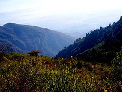
Margalla Hills National Park
| Margalla Hills National Park, Islamabad - Pakistan. | ||||||
|---|---|---|---|---|---|---|
|
IUCN category V (protected landscape/seascape)
|
||||||
Clockwise from left: Pakistan Monument, Blue Area is the commercial center of the city, National Assembly of Pakistan, Faisal Mosque, Margalla Hills National Park
Margalla hills
|
||||||
|
Map of Pakistan
|
||||||
| Location | Northern Pakistan | |||||
| Nearest city | Islamabad | |||||
| Coordinates | 33°43′52″N 72°56′13″E / 33.731°N 72.937°ECoordinates: 33°43′52″N 72°56′13″E / 33.731°N 72.937°E | |||||
| Area | 17,386 ha (67.13 sq mi) | |||||
| Established | 1980 | |||||
Margalla Hills National Park (MHNP) is a national park located on the north of the Islamabad City, within the Islamabad Capital Territory in Pakistan. The park includes the Margalla Hills which form's the foothills of the Himalayas, along with Shakarparian Park and Rawal Lake.
Established in 1980, MHNP cover's approximately 17,386 hectares (67.13 sq mi), Tilla Charouni with a height of 1,604m is tallest peak in the park. MHNP is a popular tourist destination, with Daman-e-Koh and Pir Sohawa serve as popular hill stations, while Shakarparian Cultutal Complex and Lake View Park are popular picnic spots.
The park is rich in biodiversity especially rich in Sino-himalayan fauna, most notably gray goral, barking deer and the Leopard. Combined MHNP is home to around 600 plant species, 250 bird varieties, 38 mammals and 13 species of reptiles.PTDC is currently constructing a chairlift project in the park.
Instituted in 1980, the Margalla Hills National Park comprises the Margalla Hills (12605 hectares) the Rawal Lake, and Shakarparian Sports and Cultural complex. Located in Islamabad, the capital of Pakistan. The hill range nestles between an elevation of 685 meters at the western end and 1,604 meters on its east.
Millions of years ago, these mountain peaks didn’t exist. The Asian continent was mostly intact, but Indian subcontent was an island floating off the coast of Australia. Around 220 million years ago, around the time that Pangea was breaking apart, subconetent started to move northwards. It travelled some 6,000 kilometres before it finally collided with Asia around 40 to 50 million years ago. Then, part of the Indian landmass began to go beneath the Asian one, moving the Asian landmass up, which resulted in the rise of the Himalayas. It is thought that India’s coastline was denser and more firmly attached to the seabed, which is why Asia’s softer soil was pushed up rather than the other way around.How the Himalayas Were Formed The rock formations are 40 million years old, and fossils of marine life abound, it is a clear indication that before the content collision around 40 to 50 Million years ago, these hills were the seabed of the ancient ocean. Fossils of seashells, plants, petrified wood and early sea life Yorgia waggoneri are abound.
...
Wikipedia


