Marengo County, Alabama
| Marengo County, Alabama | |
|---|---|

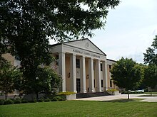
Marengo County Courthouse in Linden
|
|
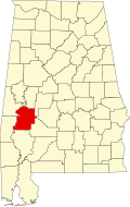
 Location in the U.S. state of Alabama |
|
 Alabama's location in the U.S. |
|
| Founded | February 6, 1818 |
| Named for | Battle of Marengo |
| Seat | Linden |
| Largest city | Demopolis |
| Area | |
| • Total | 983 sq mi (2,546 km2) |
| • Land | 977 sq mi (2,530 km2) |
| • Water | 5.8 sq mi (15 km2), 0.6% |
| Population (est.) | |
| • (2015) | 20,028 |
| • Density | 22/sq mi (8/km²) |
| Congressional district | 7th |
| Time zone | Central: UTC-6/-5 |
| Website | marengocountyal |
|
Footnotes:
|
|
Footnotes:
Marengo County is a county of the U.S. state of Alabama. As of the 2010 census, the population was 21,027. The largest city is Demopolis and the county seat is Linden. It is named in honor of the battlefield of the site of Battle of Marengo near Turin, Italy, where the Napoleon Bonaparte defeated the Austrians on June 14, 1800.
Marengo County was created by the Alabama Territorial legislature on February 6, 1818, from land acquired from the Choctaw Indians by the Treaty of Fort St. Stephens on October 24, 1816. The name of the county commemorates Napoleon's victory at the Battle of Marengo over the Austrian armies on June 14, 1800. This name was chosen in honor of the first European-American settlers, Bonapartists exiled from France after Napoleon's downfall, who in 1817 settled the area around Demopolis. They were trying to develop a Vine and Olive Colony.
The county seat was originally known as the Town of Marengo, but in 1823 the name was changed to Linden. Linden is a shortened version of Hohenlinden, scene of the Battle of Hohenlinden, a French victory in Bavaria on December 3, 1800 during Napoleon's campaign. County courthouse fires occurred in 1848 and 1965, but most of the courthouse records were in a vault and largely saved in both instances.
...
Wikipedia
