Marches Way
| Marches Way | |
|---|---|

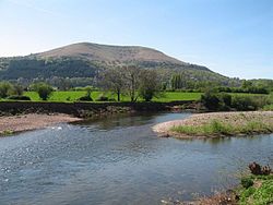
The trail follows the River Usk near Abergavenny
|
|
| Length | 218 mi (351 km) |
| Location | Wales & Midlands, England |
| Trailheads |
Chester 53°11′49″N 2°52′48″W / 53.1969°N 2.8799°W Cardiff 51°29′06″N 3°11′02″W / 51.485°N 3.184°W |
| Use | Hiking |
| Hiking details | |
| Season | All year |
The Marches Way is a partially waymarked long distance footpath in the United Kingdom. It runs 351 kilometres / 218 miles through the Welsh–English borderlands, traditionally known as the Welsh Marches and links the cities of Chester in the north and Cardiff in the south.
The route starts at Chester at Chester railway station and then follows the valley of the River Dee, Wales southwards before turning east into Malpas, Cheshire and down to Whitchurch, Shropshire before roughly following the B5476 road south to Shrewsbury via Wem. Once past Shrewsbury, the path scales the Long Mynd before entering Church Stretton and the Wenlock Edge before entering Craven Arms, where one has excellent views of Flounder's Folly. The path then passes Stokesay Castle as it heads towards Ludlow. From Ludlow the route winds through the Mortimer Forest as it heads towards Leominster. From here the path climbs Dinmore Hill, crossing the A49 road as it navigates towards Hereford. The path passes through the town centre of Hereford, picking up the River Wye before heading towards Abbey Dore and Abergavenny where the path skirts the outer edge of the Brecon Beacons National Park, climbing and running along the ridge of the Skirrid mountain. The way then follows the Monmouthshire and Brecon Canal to Pontypool before heading towards Caerleon and Newport via the Llandegfedd Reservoir. The path then heads towards its end point at Cardiff Central Railway Station via Caerphilly Common and Castell Coch at Tongwynlais.
...
Wikipedia
