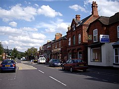
Craven Arms
| Craven Arms | |
|---|---|
 Corvedale Road |
|
| Craven Arms shown within Shropshire | |
| Population | 2,289 |
| OS grid reference | SO432828 |
| Civil parish |
|
| Unitary authority | |
| Ceremonial county | |
| Region | |
| Country | England |
| Sovereign state | United Kingdom |
| Post town | CRAVEN ARMS |
| Postcode district | SY7 |
| Dialling code | 01588 |
| Police | West Mercia |
| Fire | Shropshire |
| Ambulance | West Midlands |
| EU Parliament | West Midlands |
| UK Parliament | |
Craven Arms is a small town and civil parish in Shropshire, England, on the A49 road and the Welsh Marches railway line, which link it north and south to the larger towns of Shrewsbury and Ludlow respectively. The Heart of Wales railway line joins the Welsh Marches line at Craven Arms and the town is served by Craven Arms railway station. The town is enclosed to the north by the Shropshire Hills Area of Outstanding Natural Beauty, and to the south is the fortified manor house of Stokesay Castle.
Craven Arms is a market town for the surrounding rural area, with a number of shops, banks, estate agents, a supermarket, an abattoir and many commercial/light industrial businesses. It is also a visitor destination, being home or nearby to a number of attractions, and being central for visitors to the area of outstanding natural beauty. It describes itself as the "Gateway to the Marches".
Craven Arms is a relatively new town (for Shropshire), being only a small village "Newton" on a map of 1695. The settlement grew when the railways came during the mid to late 19th century, making it a railway town. Newton or Newtown is still the name for the southeastern part of the present day town, while the northern part is called Newington or New Inn (another small village which existed prior to the town). The town takes its name from the Craven Arms Hotel, situated on the junction of the A49 and B4368 roads, which in turn is named after the Lords Craven (who owned nearby Stokesay Castle).
...
Wikipedia

