Malpas, Cheshire
| Malpas | |
|---|---|
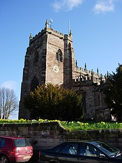
 St Oswald's Church, Malpas from the southwest |
|
| Malpas shown within Cheshire | |
| Population | 1,673 (2011) |
| OS grid reference | SJ487472 |
| Civil parish |
|
| Unitary authority | |
| Ceremonial county | |
| Region | |
| Country | England |
| Sovereign state | United Kingdom |
| Post town | MALPAS |
| Postcode district | SY14 |
| Dialling code | 01948 |
| Police | Cheshire |
| Fire | Cheshire |
| Ambulance | North West |
| EU Parliament | North West England |
| UK Parliament | |
Malpas is a large village that used to be a market town. It is also a civil parish in the unitary authority of Cheshire West and Chester and the ceremonial county of Cheshire, England. The parish lies on the border with Shropshire and Wales. The name is from Old French and means "bad/poor" (mal) and "passage/way" (pas).
There is no evidence for Roman settlement in Malpas, but it is known that the Roman Road from Bovium (Tilston) and Mediolanum (Whitchurch) passes through the village.
Dedications to St Oswald are thought to be associated with Æthelræd II (879–911), also known as Earl Aethelred of Mercia and Æthelflæd of Mercia (911–918); they are known to have encouraged the growth of this cult along the Welsh border in places such as Hereford and Shrewsbury. This may indicate that Malpas was not a Norman 'New Town', but an Anglo-Saxon burh.
After the Norman conquest of 1066 Malpas is recorded as being called Depenbech and is mentioned in the Domesday book of 1086 as belonging to Robert FitzHugh, Baron of Malpas. Malpas and other holdings were given to his family for defensive services along the Welsh border. The Cholmondeley family who still live locally at Cholmondeley Castle are reputed to be descended from Robert FitzHugh.
A concentrated line of castles protected Cheshire's western border from the Welsh; these included motte-and-bailey castles at Shotwick, Dodleston, Aldford, Pulford, Shocklach, Oldcastle and Malpas. The earthworks of Malpas Castle are still to be found to the north of St. Oswald's Church.
...
Wikipedia

