Mar Vista, Los Angeles
| Mar Vista | |
|---|---|
| Neighborhood of Los Angeles | |
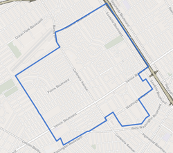
 Mar Vista as mapped by the Los Angeles Times |
|
| Location within Western Los Angeles | |
| Coordinates: 34°00′17″N 118°25′48″W / 34.00472°N 118.43°W |
Mar Vista is a residential and commercial neighborhood on the Westside of Los Angeles, California. It is the home of Venice High School, two private schools, a branch public library and a city park.
According to the Mapping L.A. project of the Los Angeles Times, Mar Vista is adjoined on the northeast by Palms, on the east, southeast and south by Culver City, on the west by Venice and on the northwest by Santa Monica.
Mar Vista's street and other boundaries are: the San Diego Freeway to the Culver City boundary at Venice Boulevard on the northeast, the Culver City line on the southeast, Walgrove Avenue on the southwest and the Santa Monica city boundary on the northwest. The northern apex of the Mar Vista neighborhood is at the San Diego Freeway and National Boulevard and the southern is at Washington Boulevard and Tivoli Avenue. The Zip Code for Mar Vista California is 90066.
Relation of Mar Vista to nearby places, not necessarily contiguous:
The 2000 U.S. census counted 35,492 residents in the 2.9-square-mile Mar Vista neighborhood—an average of 12,259 people per square mile, about the norm for Los Angeles; in 2008, the city estimated that the population had increased to 37,447. The median age for residents was 35, considered the average for Los Angeles; the percentage of residents aged 19 through 34 was among the county's highest.
The neighborhood was highly diverse ethnically, but the percentage of Asian people was high for the county. The breakdown was whites, 51.3%; Latinos, 29.1%; Asians, 12.8%, blacks, 3.5%; and others, 3.4%. Mexico (36%) and Korea (6%) were the most common places of birth for the 33.5% of the residents who were born abroad—considered an average figure for Los Angeles.
...
Wikipedia

