Manor, Texas
| Manor, Texas | |
|---|---|
| City | |

Manor City Hall
|
|
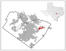
 Location of Manor, Texas |
|
| Coordinates: 30°20′35″N 97°33′24″W / 30.34306°N 97.55667°WCoordinates: 30°20′35″N 97°33′24″W / 30.34306°N 97.55667°W | |
| Country | United States |
| State | Texas |
| County | Travis |
| Founded | 1872 |
| Government | |
| • Mayor | Rita G Jonse |
| • City Manager | Thomas Bolt |
| Area | |
| • Total | 7.35 sq mi (18.48 km2) |
| • Land | 7.35 sq mi (18.48 km2) |
| • Water | 0.0 sq mi (0.0 km2) |
| Elevation | 531 ft (162 m) |
| Population (2014 Estimate) | |
| • Total | 7,452 |
| • Density | 1,013.9/sq mi (403.3/km2) |
| Time zone | Central (CST) (UTC-6) |
| • Summer (DST) | CDT (UTC-5) |
| ZIP code | 78653 |
| Area code(s) | 512 & 737 |
| FIPS code | 48-46440 |
| GNIS feature ID | 1340895 |
| Website | Official Website |
Manor (/ˈmeɪnər/ MAY-ner) is a city in Travis County, Texas, United States. Manor is located 12 miles northeast of Austin and is part of the Austin-Round Rock metropolitan area. The population was 5,037 at the 2010 census. Manor is one of the faster-growing suburbs of Austin.
Manor is located along US Hwy. 290 at 30°20′35″N 97°33′24″W / 30.343071°N 97.556710°W (30.343071, -97.556710), 12 miles (19 km) east of downtown Austin. According to the United States Census Bureau, the city has a total area of 7.35 square miles (18.48 km2), all of it land.
In 2006, the first parts of a central Texas tollway system opened, which included State Highway 130 and State Highway 45. These roads increased accessibility to Manor. A Walmart was built on the east side of town near the junction of U.S. Highway 290 and FM 973. Manor Medical Center broke ground in 2013.
...
Wikipedia
