Mangualde
| Mangualde | |||
|---|---|---|---|
| Municipality | |||

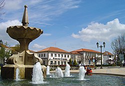
The main square in Mangualde, Largo Dr. Couto, location of the municipal authority
|
|||
|
|||
 |
|||
| Coordinates: 40°36′15″N 7°45′40″W / 40.60417°N 7.76111°WCoordinates: 40°36′15″N 7°45′40″W / 40.60417°N 7.76111°W | |||
| Country |
|
||
| Region | Centro | ||
| Subregion | Dão-Lafões | ||
| Intermunic. comm. | Viseu Dão Lafões | ||
| District | Viseu | ||
| Parishes | 12 | ||
| Government | |||
| • President | João Nuno Ferreira Gonçalves Azevedo (PS) | ||
| Area | |||
| • Total | 219.26 km2 (84.66 sq mi) | ||
| Highest elevation | 766 m (2,513 ft) | ||
| Lowest elevation | 225 m (738 ft) | ||
| Population (2011) | |||
| • Total | 19,880 | ||
| • Density | 91/km2 (230/sq mi) | ||
| Time zone | WET/WEST (UTC+0/+1) | ||
| Postal code | 3534 | ||
| Area code | 232 | ||
| Website | http://www.cmmangualde.pt | ||
Mangualde (Portuguese pronunciation: [mɐ̃ˈɡwaɫd(ɨ)]) is a municipality in the subregion of Dão-Lafões (historical Beira Interior), central region of Portugal. The population in 2011 was 19,880, in an area of 219.26 km².
The region of Mangualde has been a crossroads of many peoples: Viriathus's warriors, transhumance shepards, Romans, Moors and Christian conquerors, including soldiers from Castile or France, or even pilgrims. Mangualde was an important outpost in the textile trade from Covilhã, Seia and Gouveia. Its location, on the frontier with the Serra da Estrela and marginalized by its geography to north, was nonetheless a channel of pre-historic cultures associated with the dolmens that are found through the region. The mount of Nossa Senhora do Castelo, is one such example of the pre-Romanic castros that were used by the early settlers, then reappropriated by the Roman soldiers as forts.
The Romans, attracted by the riches of the Iberian Peninsula (primarily minerals), began to progressively occupy the region until the 5th century, when barbarians invaded the peninsula. Romanization of these lands resulted in a diffusion and assimilation of cultural structures, political hierarchies, social institutions, the economy and religious services. Mangualde was one of the principal access-ways in Lusitânia, connecting Emerita Augusta (Mérida) to Bracara Augusta (Braga). Along the roadway, millennium or road markers were discovered in Abrunhosa-a-Velha, noting the repairs completed to the road under emperors Hadrian and Numerian. Similarly, a second via crossed the Alcafache bridge (a Roman-built structure) towards Espinho, while another crossed the rivers from the north.
After the barbarian invasions, the region was also taken by Muslim forces, who occupied the area of Nossa Senhora do Castelo. This place became known by the military governor, Zurara, and the fort constructed on the site referred to asCastelo de Zurara (or also Castelo de Azurara), overtime becoming transliterated in ancient name of the municipality: Azurara da Beira. In 1058, the medieval castle was conquered from the Moors, by the forces of Ferdinand I of León and Castile. By 1102, Count Henrique and Countess Theresa, before the independence of Portugal, issued a foral to the lands of Zurara, between the Dão and Mondego Rivers. It was later confirmed by Afonso II, when the monarch issued his ordinances in February 1217, and by King Manuel in 1514, during his reforms. When Christian forces finally took the fortress, they discovered a privileged lookout that provided line-of-sight for thousands of miles.
...
Wikipedia


