Mangla Dam
| Mangla Dam | |
|---|---|

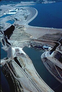
Mangla Dam Aerial View
|
|
|
Location of Mangla Dam in Pakistan
|
|
| Country | Pakistan |
| Location | Mangla, Jammu & Kashmir |
| Coordinates | 33°08′31″N 73°38′42″E / 33.142083°N 73.645015°ECoordinates: 33°08′31″N 73°38′42″E / 33.142083°N 73.645015°E |
| Status | Operational |
| Construction began | 1961 |
| Opening date | 1967 |
| Dam and spillways | |
| Type of dam | Embankment dam |
| Impounds | Jhelum River |
| Height | 147 m (482 ft) |
| Length | 3,140 m (10,302 ft) |
| Reservoir | |
| Creates | Mangla Lake |
| Total capacity | 9.12 km3 (7,390,000 acre·ft) |
| Surface area | 97 sq mi (251 km2) |
| Power station | |
| Turbines | 10 x 100 MW |
| Installed capacity | 1,150 MW (15% overload) 1,500 MW (max. planned) |
The Mangla Dam (Urdu: منگلا بند) is a multipurpose dam located on the Jhelum River in the Mirpur District of Jammu & Kashmir, Pakistan. It is the 7th largest dam in the world. The dam got it's name from a village Mangla which was named after "Mangla Devi", a Hindu Goddess. The project was designed and supervised by Binnie & Partners of London (the team led by partner Geoffrey Binnie), and it was built by Mangla Dam Contractors, a consortium of 8 U.S. construction firms, sponsored by Guy F. Atkinson Company of South San Francisco.
As part of the Indus Waters Treaty signed in 1960, India gained rights to the waters of the Ravi, Sutlej and Beas rivers, while Pakistan, in addition to waters of the above three rivers within Pakistan and some monetary compensation, received the rights to develop the Jhelum, Chenab and Indus river basins. Until 1967, the entire irrigation system of Pakistan was fully dependent on unregulated flows of the Indus and its major tributaries. The agricultural yield was very low for a number of reasons, the most important being a lack of water during critical growing periods. This problem stemmed from the seasonal variations in the river flow due to monsoons and the absence of storage reservoirs to conserve the vast amounts of surplus water during those periods of high river discharge.
...
Wikipedia

