Mandi Bahauddin
|
Mandi Bahauddin منڈی بهاؤالدین |
|
|---|---|
| City | |
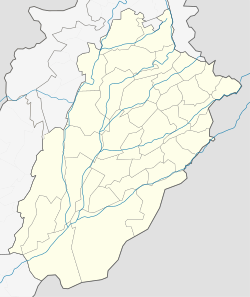
| Location within Pakistan | |
| Coordinates: 32°34′47″N 73°28′53″E / 32.57972°N 73.48139°ECoordinates: 32°34′47″N 73°28′53″E / 32.57972°N 73.48139°E | |
| Country | Pakistan |
| Province | Punjab |
| District | Mandi Bahauddin District |
| Established | 1506 AD |
| NA/PP | 2/5 N.A (108,109) P.P(116,117,118,119,120) |
| No. of Towns | |
| Government | |
| • Type | City District |
| • Union Councils | 27 |
| Area | |
| • Total | 7,623 km2 (2,943 sq mi) |
| Elevation | 204 m (669 ft) |
| Population (2015) | |
| • Total | 400,000 |
| • Density | 52/km2 (140/sq mi) |
| Demonym(s) | Bahauddinian |
| Time zone | PST (UTC+5) |
| Postal code | 50400 |
| Dialling code | 0546 |
Mandi Bahauddin (Punjabi, Urdu: منڈی بهاؤالدین) is a city in central Punjab, Pakistan.It is also the capital of Mandi Bahauddin District. The city is some 220 metres above the sea level and is located in central Punjab, between the rivers Jhelum (north 12 km) and Chenab (south 39 km).
The recorded history of Mandi Bahauddin goes back to the era before Common Era, connecting the region with the historic figure of Alexander the Great. Some 8 km northwest of the modern-day Mandi Bahauddin town, village Mong on the southern bank of Jhelum River (Greek Hydaspes), the battle Battle of the Hydaspes River was fought between Raja Porus (Sanskrit Paurava) and Alexander. This historic battle of Hydaspes River, which Indian sources refer to as the "Battle of Jhelum", took place in 326 BCE. The kingdom of Raja Porus was situated in the northern Punjab of modern Pakistan. This battle proved the last major fight of Alexander's career, for the Macedonians, after being put up a fierce resistance by Porus' soldiery and having heard of a massive 4,000 elephant force mustered by eastern kingdoms, refused to march further east i.e. Ganges Plains.
...
Wikipedia


