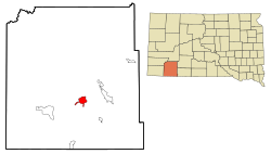
Manderson-White Horse Creek, South Dakota
|
Manderson-White Horse Creek, South Dakota Oyúȟpe |
|
|---|---|
| CDP | |
 Location in Oglala Lakota County and the state of South Dakota |
|
| Coordinates: 43°13′44″N 102°28′24″W / 43.22889°N 102.47333°WCoordinates: 43°13′44″N 102°28′24″W / 43.22889°N 102.47333°W | |
| Country | United States |
| State | South Dakota |
| County | Oglala Lakota |
| Area | |
| • Total | 5.7 sq mi (14.8 km2) |
| • Land | 5.7 sq mi (14.8 km2) |
| • Water | 0 sq mi (0 km2) |
| Population (2010) | |
| • Total | 626 |
| • Density | 109.8/sq mi (42.3/km2) |
| Time zone | Mountain (MST) (UTC-7) |
| • Summer (DST) | MDT (UTC-6) |
| Area code(s) | 605 |
| FIPS code | 46-40550 |
Manderson-White Horse Creek (Lakota: oyúȟpe; the name of a band of the Oglala) is a census-designated place (CDP) in Oglala Lakota County, South Dakota, United States. The population was 626 at the 2010 census. Oglala Lakota tribesman, Kicking Bear died here on May 28, 1904. He fought in several battles during the Black Hills War, including Battle of the Greasy Grass. His nephew, Felix Flying Hawk owned a ranch.
According to the Federal Writers' Project, the origin of the name Manderson is obscure.
Manderson-White Horse Creek is located at 43°13′44″N 102°28′24″W / 43.22889°N 102.47333°W (43.228781, -102.473216).
According to the United States Census Bureau, the CDP has a total area of 5.7 square miles (14.8 km²), all land.
Manderson has been assigned the ZIP code 57756.
As of the census of 2000, there were 626 people, 109 households, and 97 families residing in the CDP. The population density was 109.9 people per square mile (42.4/km²). There were 116 housing units at an average density of 20.4/sq mi (7.9/km²). The racial makeup of the CDP was 1.12% White, 98.72% Native American, and 0.16% from two or more races. Hispanic or Latino of any race were 1.76% of the population.
...
Wikipedia
