Manayunk Main Street Historic District
| Manayunk Neighborhood of Philadelphia |
|
| Former Borough | |
|
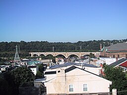
Manayunk skyline
|
|
| Country | United States |
|---|---|
| State | Pennsylvania |
| County | Philadelphia |
| Coordinates | 40°01′35″N 75°13′25″W / 40.02639°N 75.22361°WCoordinates: 40°01′35″N 75°13′25″W / 40.02639°N 75.22361°W |
| Population | 10,154 (2010) |
| Timezone | EST (UTC-5) |
| - summer (DST) | EDT (UTC-4) |
| ZIP code | 19127 |
| Area code | 215 |
|
Map of Philadelphia County, Pennsylvania highlighting Manayunk Borough prior to the Act of Consolidation, 1854
|
|
|
Manayunk Main Street Historic District
|
|

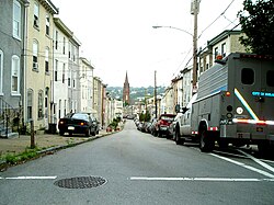
Dupont Street, in Manayunk, Philadelphia, PA, USA
|
|
| Location | Roughly bounded by Reading RR, Flat Rock Dam, Schuylkill River, and Lot 4025 Main St. Philadelphia, Pennsylvania |
|---|---|
| Coordinates | 40°1′50″N 75°13′58″W / 40.03056°N 75.23278°W |
| Area | 112 acres (45 ha) |
| Architect | Multiple |
| Architectural style | Classical Revival, Late Victorian |
| NRHP Reference # | 83002274 |
| Added to NRHP | March 18, 1983 |
Manayunk (/ˈmænijʌŋk/) is a neighborhood in the northwestern section of the city of Philadelphia, Pennsylvania in the United States. Located on the banks of the Schuylkill River, it contains the first canal begun in the United States (although not the first completed due to budget problems). The area's name comes from the language of the Lenape Indians (later called the Delaware Indians by Europeans). In 1686-dated papers between William Penn and the Lenape, the Lenape referred to the Schuylkill River as "Manaiung", their word for "river", which literally translates as "place to drink"; the word was later altered and adopted as the town's name.
Although historically a working class community, in recent years the neighborhood has been substantially gentrified. While there is still a working class population within the neighborhood, the population has shifted to younger upper middle class professionals and families. Additionally, the nightlife in Manayunk draws visitors from all over the Delaware Valley, as well as international visitors.
Manayunk was originally a community in Roxborough Township, Philadelphia County, situated near the Schuylkill River, south of the Wissahickon Creek. The land that would become Manayunk was first bought from William Penn in 1685-1686 and then transferred to the family of William Levering. A large part of that land was then sold to Levering's son, Jacob, in 1716. Soon, the younger Levering built the first house in Manayunk, on the north side of Green Lane, west of Silverwood Street. The growing town was known as Flat Rock in 1810, from a peculiar flat rock lying on the lower side of the bridge. This was subsequently called Flat Rock Bridge. The bridge was part of the Flat Rock Turnpike connecting Roxborough Township with Merion Township. The bridge was demolished in 1850.
...
Wikipedia


