Lower Merion Township, Pennsylvania
|
Lower Merion Lower Merion Township |
|||
|---|---|---|---|
| Township | |||

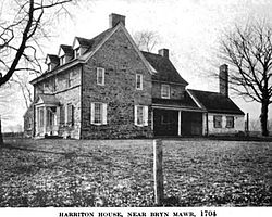
Harriton House as it appeared ca. 1919.
|
|||
|
|||
| Motto: "A First-Class Township" | |||
 Location of Lower Merion Township in Montgomery County |
|||
| Location of Lower Merion Township in Pennsylvania | |||
| Coordinates: 39°59′00″N 75°15′59″W / 39.98333°N 75.26639°WCoordinates: 39°59′00″N 75°15′59″W / 39.98333°N 75.26639°W | |||
| Country |
|
||
| State |
|
||
| County |
|
||
| Settled | 1682 | ||
| Incorporated | 1713 | ||
| Government | |||
| • Township Manager | Ernie McNeely | ||
| • Board President | Daniel Bernheim | ||
| Area | |||
| • Total | 23.9 sq mi (62 km2) | ||
| • Land | 23.7 sq mi (61 km2) | ||
| • Water | 0.2 sq mi (0.5 km2) | ||
| Elevation | 200 ft (60 m) | ||
| Population (2010) | |||
| • Total | 57,825 | ||
| • Density | 2,400/sq mi (930/km2) | ||
| Time zone | EST (UTC-5) | ||
| • Summer (DST) | EDT (UTC-4) | ||
| Area code | 610 and 484 | ||
| Website | www |
||
Lower Merion Township is a township in Montgomery County, Pennsylvania and part of the Pennsylvania Main Line. As of the 2010 U.S. Census, the township had a total population of 57,825. Lower Merion has the 5th highest per-capita income and the 12th highest median household income in the country with a population of 50,000 or more.
The name Merion originates with the county of Merioneth in north Wales. Merioneth is an English-language translation of the Welsh Meirionnydd.
Lower Merion, along with Upper Darby, Haverford, Cheltenham together form as the major inner ring suburbs of Philadelphia.
Lower Merion Township was first settled in 1682 by Welsh Quakers who were granted a tract of land (the Welsh Tract) by William Penn. In 1713, Lower Merion was established as an independent Township with about 52 landholders and tenants. In 1900, the Township was incorporated as a Township of the First Class. Lower Merion is home to the oldest continuously used place of worship in the United States, the Merion Friends Meeting House, used continuously since 1695.
The Mill Creek Historic District, and Seville Theatre are listed on the National Register of Historic Places.Green Hill Farms was added in 2011.
According to the United States Census Bureau, the township has a total area of 23.9 square miles (61.8 km²), of which, 23.7 square miles (61.4 km²) of it is land and 0.2 square miles (0.4 km²) of it (0.67%) is water.
...
Wikipedia


