Haverford Township, PA
| Haverford Township | ||
| The Township of Haverford, Pennsylvania | ||
|
Home Rule Municipality First Class Township |
||
|
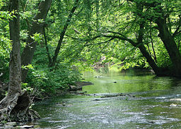
Darby Creek in Haverford Township
|
||
|
||
| Country | ||
|---|---|---|
| State | ||
| County | Delaware County, Pennsylvania | |
| Elevation | 289 ft (88.1 m) | |
| Coordinates | 39°59′00″N 75°17′59″W / 39.98333°N 75.29972°WCoordinates: 39°59′00″N 75°17′59″W / 39.98333°N 75.29972°W | |
| Area | 10.0 sq mi (25.9 km2) | |
| - land | 10.0 sq mi (26 km2) | |
| - water | 0.0 sq mi (0 km2), 0% | |
| Population | 48,491 (2010) | |
| Density | 4,844.6/sq mi (1,870.5/km2) | |
| Settled | 1682 | |
| Timezone | EST (UTC-5) | |
| - summer (DST) | EDT (UTC-4) | |
|
Location in Delaware County and the state of Pennsylvania.
|
||
|
Location of Pennsylvania in the United States
|
||
|
Website: www |
||
Haverford Township is a Home Rule Municipality township in Delaware County, Pennsylvania, United States. Haverford is named after the town of Haverfordwest in Wales, UK. It is a commuting suburb located due west of Philadelphia and is officially known as the Township of Haverford. Despite being under a home rule charter since 1977, it continues to operate under a Board of Commissioners divided into wards, as do "First Class" townships that are still under the Pennsylvania Township Code. Haverford Township was founded in 1682 and incorporated in 1911.
It's a Main Line suburb of Philadelphia, so named as they were located along the Pennsylvania Railroad Main Line. In northern Delaware County, the township is also skewered by US Route 30 which intersects with Interstate 476 towards its western border.
Haverford Township contains portions of the unincorporated communities of Haverford, Ardmore, and Wynnewood as well as the census designated places of Bryn Mawr and Drexel Hill. The unincorporated community of Havertown lies wholly within Haverford Township. The township population as of the 2010 census was 48,491.
...
Wikipedia


