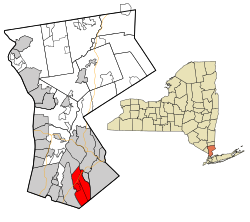
Mamaroneck, NY
| Mamaroneck | ||
|---|---|---|
| Town | ||
|
||
| Nickname(s): Larchmont | ||
| Motto: Tigers | ||
 Location of Mamaroneck, New York |
||
| Coordinates: 40°56′57″N 73°44′01″W / 40.94917°N 73.73361°WCoordinates: 40°56′57″N 73°44′01″W / 40.94917°N 73.73361°W | ||
| Country | United States | |
| State | New York | |
| County | Westchester | |
| Government | ||
| • Supervisor | Nancy Seligson (D) | |
| Area | ||
| • Total | 14.0 sq mi (36.4 km2) | |
| • Land | 6.6 sq mi (17.1 km2) | |
| • Water | 7.4 sq mi (19.2 km2) | |
| Elevation | 0 ft (0 m) | |
| Population (2010) | ||
| • Total | 29,156 | |
| • Density | 2,100/sq mi (800/km2) | |
| Time zone | Eastern (EST) (UTC−5) | |
| • Summer (DST) | EDT (UTC−4) | |
| ZIP Codes | 10538, 10543, 10583 | |
| Area code(s) | 914 | |
| Website | www.TownOfMamaroneck.org | |
Mamaroneck (/məˈmærənɛk/, mə-MAR-ə-nek) is a town in Westchester County, New York, United States.
The population was 29,156 at the 2010 census. There are two villages contained within the town: Larchmont and the Village of Mamaroneck (part of which is located in the adjacent town of Rye). The majority of the town's land area is not within either village, constituting an unincorporated area, although a majority of the population lives within the villages. Legally, the unincorporated section and the villages constitute the town as a political and governmental subdivision of New York State. The town is led by a town board, composed of five town board members, which includes the Town Supervisor, Nancy Seligson.
Much of the unincorporated section of the town receives its mail via the Larchmont Post Office and thereby has a Larchmont address.
The Town of Mamaroneck was ranked first in the list of the top 10 places to live in New York State for 2014 according to the national online real estate brokerage Movoto.
According to the United States Census Bureau, the town has a total area of 14.0 square miles (36 km2), of which 6.6 square miles (17 km2) is land and 7.4 square miles (19 km2), or 52.85%, is water. The unincorporated area of the town measures 5.17 square miles (13.4 km2).
...
Wikipedia
