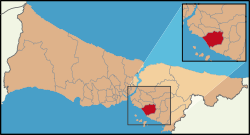
Maltepe, Istanbul
| Maltepe | |
|---|---|
| district | |
 Location of Maltepe in Istanbul |
|
| Location of Maltepe in Istanbul | |
| Coordinates: 40°55′30″N 29°09′06″E / 40.92500°N 29.15167°ECoordinates: 40°55′30″N 29°09′06″E / 40.92500°N 29.15167°E | |
| Country | Turkey |
| City | Istanbul |
| Government | |
| • Mayor | Ali Kılıç (CHP) |
| • Governor | Ahmet Okur |
| Area | |
| • District | 123.41 km2 (47.65 sq mi) |
| Population (2012) | |
| • District | 460,955 |
| • District density | 3,700/km2 (9,700/sq mi) |
| Time zone | EET (UTC+2) |
| • Summer (DST) | EEST (UTC+3) |
| Area code(s) | 0-216 |
| Website |
www |
Maltepe is a district in the suburbs of Istanbul, Turkey between Kadıköy and Kartal on the Marmara sea. Its neighbours are Kadıköy to the west and Kartal to the east. The mayor of Maltepe is Ali Kılıç (CHP). Maltepe used to border Ümraniye from the northwest between 1992 and 2004. However, the Yeni Çamlıca quarter changed to Ümraniye in 1994 and the Ferhatpaşa quarter passed to Samandıra where bounded to Kartal district in 2004. Ferhatpaşa's secession led to ending of neighbourhood between Maltepe and Ümraniye.
In Byzantine times, the area was known as Bryas (Greek: Βρύας). In ca. 837, the emperor Theophilos (r. 829–842) erected here a palace in Arab style, inspired by the palaces of the Abbasids in Baghdad, described to him by his ambassador to the Abbasid court, John Grammatikos. A ruin in nearby Küçükyalı has been identified as it.
This coast has been a retreat from the city since Byzantine and Ottoman times, and right up until the 1970s was a rural area peppered with summer homes for wealthy Istanbul residents. Being on the suburban railway line Maltepe was a favourite spot for day-trippers or weekenders to visit the beach and many summer houses were built there. Many of these houses remain but Maltepe is no longer a beach retreat: the Marmara sea is no longer clean enough to swim in, although the sea-front is still pleasant to sit, drink tea and enjoy the views of the Princes Islands.
The population grew rapidly from the 70's onwards when, following the building of the Bosphorus Bridge, it became possible to commute from here to the city. Buses along the E5 highway to the bridge, and minibuses to the ferry docks at Kadıköy now carry lower-middle class commuters (the wealthier preferring to live in smarter areas nearer the city, in Kadıköy itself). These people live either in quiet tree-lined streets of four- to six-storey apartment building with gardens around them, or in modern housing complexes with tennis-courts, children's playgrounds and security guards on the gate.
...
Wikipedia

