Mahnomen, Minnesota
| Mahnomen, Minnesota | |
|---|---|
| City | |

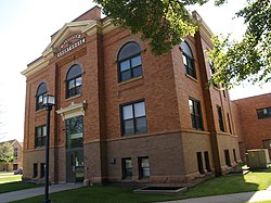
Mahnomen County Courthouse in Mahnomen
|
|
 Location of the city of Mahnomen within Mahnomen County, Minnesota |
|
| Coordinates: 47°18′57″N 95°58′10″W / 47.31583°N 95.96944°W | |
| Country | United States |
| State | Minnesota |
| County | Mahnomen |
| Government | |
| • Mayor | Martin Warnsholz |
| Area | |
| • Total | 1.06 sq mi (2.75 km2) |
| • Land | 1.06 sq mi (2.75 km2) |
| • Water | 0 sq mi (0 km2) |
| Elevation | 1,211 ft (369 m) |
| Population (2010) | |
| • Total | 1,214 |
| • Estimate (2012) | 1,240 |
| • Density | 1,145.3/sq mi (442.2/km2) |
| Time zone | Central (CST) (UTC-6) |
| • Summer (DST) | CDT (UTC-5) |
| ZIP code | 56557 |
| Area code(s) | 218 |
| FIPS code | 27-39392 |
| GNIS feature ID | 0647385 |
Mahnomen (/məˈnoʊmən/ mə-NOH-mən) is a city in Mahnomen County, Minnesota, United States, along the Wild Rice River. The population was 1,214 at the 2010 census. It is the county seat of Mahnomen County.
U.S. Highway 59 and Minnesota State Highway 200 are two of the main routes in Mahnomen.
"Mahnomen" comes from the Ojibwe name for wild rice.
A post office called Mahnomen has been in operation since 1904.Mahnomen City Hall is listed on the National Register of Historic Places.
According to the United States Census Bureau, the city has a total area of 1.06 square miles (2.75 km2), all of it land.
As of the census of 2010, there were 1,214 people, 529 households, and 293 families residing in the city. The population density was 1,145.3 inhabitants per square mile (442.2/km2). There were 582 housing units at an average density of 549.1 per square mile (212.0/km2). The racial makeup of the city was 59.3% White, 0.2% African American, 31.2% Native American, 0.1% Asian, and 9.2% from two or more races. Hispanic or Latino of any race were 1.8% of the population.
...
Wikipedia
