Magnolia, Ohio
| Magnolia, Ohio | |
|---|---|
| Village | |

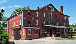
The Magnolia Flouring Mill was established by the village's founder.
|
|
 Location of Magnolia, Ohio |
|
 Location of Magnolia in Stark County |
|
| Coordinates: 40°39′9″N 81°17′46″W / 40.65250°N 81.29611°WCoordinates: 40°39′9″N 81°17′46″W / 40.65250°N 81.29611°W | |
| Country | United States |
| State | Ohio |
| Counties | Stark, Carroll |
| Area | |
| • Total | 0.87 sq mi (2.25 km2) |
| • Land | 0.87 sq mi (2.25 km2) |
| • Water | 0 sq mi (0 km2) |
| Elevation | 958 ft (292 m) |
| Population (2010) | |
| • Total | 978 |
| • Estimate (2012) | 976 |
| • Density | 1,124.1/sq mi (434.0/km2) |
| Time zone | Eastern (EST) (UTC-5) |
| • Summer (DST) | EDT (UTC-4) |
| ZIP code | 44643 |
| Area code(s) | 330 |
| FIPS code | 39-46844 |
| GNIS feature ID | 1070833 |
| Website | www |
Magnolia is a village in Carroll and Stark counties in the U.S. state of Ohio. The population was 978 at the 2010 census. It is part of the Canton–Massillon Metropolitan Statistical Area.
In 1834 Richard Elson and John W. Smith laid out the village of Magnolia in Sandy Township. In 1836, Isaac Miller platted the village of Downingville in Rose Township. The towns merged and became Magnolia on February 1, 1846. The village took its name from the local Magnolia Mills.
The Muskingum Watershed Conservancy District constructed the Magnolia Levee to protect the town from Bolivar Dam.
Magnolia is located at 40°39′9″N 81°17′46″W / 40.65250°N 81.29611°W (40.652546, -81.296119), along Sandy Creek.
According to the United States Census Bureau, the village has a total area of 0.87 square miles (2.25 km2), all land.
Magnolia lies at the intersection of State Routes 183 and 542.
As of the census of 2010, there were 978 people, 384 households, and 266 families residing in the village. The population density was 1,124.1 inhabitants per square mile (434.0/km2). There were 418 housing units at an average density of 480.5 per square mile (185.5/km2). The racial makeup of the village was 97.8% White, 0.2% African American, 0.3% Native American, 0.3% Asian, 0.1% from other races, and 1.3% from two or more races. Hispanic or Latino of any race were 1.2% of the population.
...
Wikipedia
