Madison, NJ
| Madison, New Jersey | |
|---|---|
| Borough | |
| Borough of Madison | |

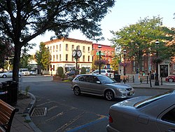
Downtown Madison
|
|
| Nickname(s): The Rose City | |
 Location in Morris County and the state of New Jersey. |
|
 Census Bureau map of Madison, New Jersey |
|
| Coordinates: 40°45′29″N 74°25′04″W / 40.7580°N 74.4178°WCoordinates: 40°45′29″N 74°25′04″W / 40.7580°N 74.4178°W | |
| Country |
|
| State |
|
| County | Morris |
| Incorporated | December 27, 1889 |
| Named for | President James Madison |
| Government | |
| • Type | Borough |
| • Body | Borough Council |
| • Mayor | Robert H. Conley (D, term ends December 31, 2019) |
| • Administrator | Raymond M. Codey |
| • Clerk | Elizabeth Osborne |
| Area | |
| • Total | 4.218 sq mi (10.926 km2) |
| • Land | 4.205 sq mi (10.891 km2) |
| • Water | 0.013 sq mi (0.035 km2) 0.32% |
| Area rank | 291st of 566 in state 24th of 39 in county |
| Elevation | 266 ft (81 m) |
| Population (2010 Census) | |
| • Total | 15,845 |
| • Estimate (2015) | 16,126 |
| • Rank | 160th of 566 in state 13th of 39 in county |
| • Density | 3,767.9/sq mi (1,454.8/km2) |
| • Density rank | 168th of 566 in state 6th of 39 in county |
| Time zone | EST (UTC−5) |
| • Summer (DST) | Eastern (EDT) (UTC−4) |
| ZIP code | 07940 |
| Area code(s) | 973 |
| FIPS code | 3402742510 |
| GNIS feature ID | 0885287 |
| Website | www |
Madison is a borough in Morris County, New Jersey, United States. As of the 2010 United States Census, the population was 15,845, reflecting a drop in population of 685 (−4.1%) from the 16,530 counted in the 2000 Census, which had in turn increased by 680 (+4.3%) from the 15,850 counted in the 1990 Census. It is known as "The Rose City" and was named in honor of President James Madison.
Native Americans occupied the areas that would become New Jersey and Madison following the retreat of the Wisconsin Glacier for many thousands of years. Settlements of the Lenape were agriculturally based following matrilineal lines.The protected lands nearby, Jockey Hollow, are what is remaining of the settlement. Occupation changed with the seasons, the variable nature of the climate, and to preserve the fertility of the rich soil. Their fishing and hunting territories were wide-ranging and similarly divided among the three clans of the matrilineal culture in this Eastern Woodland environment. Trade with these native peoples for food and furs was conducted by the Dutch during the period of colonization of New Netherland. Although the European principle of land ownership was not recognized by the Lenape, Dutch West India Company policy required their colonists to purchase land that they settled, but typically, trading relationships were established in this area, rather than Dutch settlements.
During the British colonial period, the earliest settlers of European descent arrived in this portion of the colony of New Jersey. Traditional native trails and pathways were followed as settlement began. Pressures upon the Lenape constantly drove them westward. About 1715 the village of Bottle Hill was established at the crossing of Ridgedale Avenue and Kings Road. Village governance principles followed the British model. The Luke Miller house at 105 Ridgedale Avenue is thought to be the oldest remaining home, having been built around 1730. During British colonial rule, Kings Road was a toll road that assessed fees levied by the government appointed by the English king. Farther south was the Shunpike, a road with a parallel path that was used deliberately by colonists to avoid the fees.
...
Wikipedia
