Mabton, Washington
| Mabton, Washington | |
|---|---|
| City | |

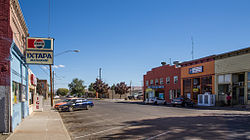
Main Street
|
|
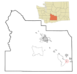
 Location of Mabton, Washington |
|
| Coordinates: 46°12′42″N 119°59′47″W / 46.21167°N 119.99639°WCoordinates: 46°12′42″N 119°59′47″W / 46.21167°N 119.99639°W | |
| Country | United States |
| State | Washington |
| County | Yakima |
| Area | |
| • Total | 0.80 sq mi (2.07 km2) |
| • Land | 0.80 sq mi (2.07 km2) |
| • Water | 0 sq mi (0 km2) |
| Elevation | 715 ft (218 m) |
| Population (2010) | |
| • Total | 2,286 |
| • Estimate (2015) | 2,302 |
| • Density | 2,857.5/sq mi (1,103.3/km2) |
| Time zone | Pacific (PST) (UTC-8) |
| • Summer (DST) | PDT (UTC-7) |
| ZIP code | 98935 |
| Area code | 509 |
| FIPS code | 53-40980 |
| GNIS feature ID | 1512417 |
| Website | City of Mabton |
Mabton is a city in Yakima County, Washington, United States. The population was 2,286 at the 2010 census. Incorporated during the first few years of the 20th century, it is located at the eastern edge of the Yakama Indian Reservation.
The Mabton area's original inhabitants were the Yakama people, who were forced onto a reservation in 1855. Mabton's existence as a town is due to the Northern Pacific Railway, which arrived in the area around 1884 and built a water tower and section house on the site. Nothing else existed at Mabton until 1892 when Sam P. Flower built a store and a warehouse. He soon became the town's first postmaster. Mabton was named by Charlie Sandburg, a Swedish railworker, who proposed the name "Mabletown" for the wife (or daughter) of a railroad official who had spoken kind words to track workers during an inspection. By 1895, Mabton had several stores, a hotel, a railroad depot and a schoolhouse. The Mabton Townsite Company, formed by Sam P. Flower and J.A. Humphrey, made the first plat in 1902, and by 1904, it had more than a dozen businesses and a newspaper. The town of Mabton officially incorporated on November 7, 1905.
Today, residents primarily are employed in occupations related to agriculture, especially hop growing and grape growing.
The Mabton School District has been the repeated beneficiary of grants from the Bill and Melinda Gates Foundation:
A small ranch near Mabton was home to the first confirmed case of mad cow disease in the United States on December 23, 2003, later confirmed to be a cow of Canadian origin imported to the U.S.
Mabton is located at 46°12'42" North, 119°59'47" West (46.211618, -119.996520). According to the United States Census Bureau, the city has a total area of 0.80 square miles (2.07 km2), all of it land.
...
Wikipedia
