Maasmond
| Nieuwe Waterweg | |
| New Waterway | |
| Canal | |
|
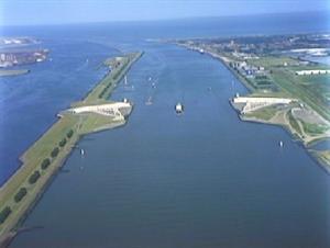
Mouth of the New Waterway at the North Sea
|
|
| Country | Netherlands |
|---|---|
| Province | South Holland |
| Source | Nieuwe Maas |
| - location | Maassluis |
| Mouth | Maasmond |
| - location | Hoek van Holland |
| Length | 20 km (12 mi) |
|
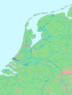
Location of Nieuwe Waterweg (including Het Scheur) in dark blue.
|
|
Coordinates: 51°56′31″N 4°11′29″E / 51.94194°N 4.19139°E
The Nieuwe Waterweg ("New Waterway") is a ship canal in the Netherlands from het Scheur (a branch of the Rhine-Meuse-Scheldt delta) west of the town of Maassluis to the North Sea at Hook of Holland: the Maasmond, where the Nieuwe Waterweg connects to the Maasgeul. It is the artificial mouth of the river Rhine.
The Nieuwe Waterweg, which opened in 1872 and has a length of approximately 20.5 kilometres (12.7 mi), was constructed to keep the city and port of Rotterdam accessible to seafaring vessels as the natural Meuse-Rhine branches silted up. The Waterway is a busy shipping route since it is the primary access to one of the busiest ports in the world, the Port of Rotterdam. At the entrance to the sea, a flood protection system called Maeslantkering has been installed (completed in 1997). There are no bridges or tunnels across the Nieuwe Waterweg.
By the middle of the 19th century, Rotterdam was already one of the largest port cities in the world, mainly because of transshipment of goods from Germany to Great Britain. The increase in shipping traffic created a capacity problem: there were too many branches in the river delta, making the port difficult to reach.
...
Wikipedia


