Münchwald
| Münchwald | ||
|---|---|---|
|
||
| Coordinates: 49°53′48″N 7°40′32″E / 49.89668°N 7.67557°ECoordinates: 49°53′48″N 7°40′32″E / 49.89668°N 7.67557°E | ||
| Country | Germany | |
| State | Rhineland-Palatinate | |
| District | Bad Kreuznach | |
| Municipal assoc. | Rüdesheim | |
| Government | ||
| • Mayor | Stephan Wagner | |
| Area | ||
| • Total | 1.46 km2 (0.56 sq mi) | |
| Elevation | 400 m (1,300 ft) | |
| Population (2015-12-31) | ||
| • Total | 316 | |
| • Density | 220/km2 (560/sq mi) | |
| Time zone | CET/CEST (UTC+1/+2) | |
| Postal codes | 55595 | |
| Dialling codes | 06706 | |
| Vehicle registration | KH | |
| Website | www.muenchwald.info | |
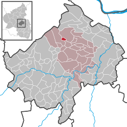
Münchwald is an Ortsgemeinde – a municipality belonging to a Verbandsgemeinde, a kind of collective municipality – in the Bad Kreuznach district in Rhineland-Palatinate, Germany. It belongs to the Verbandsgemeinde of Rüdesheim, whose seat is in the municipality of Rüdesheim an der Nahe. Münchwald is a state-recognized tourism community (Fremdenverkehrsort), and with a founding date going back only as far as the time around 1700, it is also one of the district’s newest municipalities.
Münchwald lies roughly halfway between Bad Kreuznach and Simmern, about 20 km from each, in the southern Hunsrück, right at the Soonwald on a plateau, some 400 m above sea level.
As at 31 December 2012, the 1.46 km² making up Münchwald’s municipal area broke down as follows:
Clockwise from the north, Münchwald’s neighbours are the municipalities of Spabrücken, Argenschwang and Spall, all of which likewise lie within the Bad Kreuznach district.
Also belonging to Münchwald are the outlying homesteads of Haus Gräfenbach, Kesselshäuschen and Struthof.
At New Year’s 1147, long before there was any village called Münchwald, the free noble Godebold III of Weierbach promised to take part in a crusade to the Holy Land. Since he did not keep this promise, he atoned for his sin by donating his estate, an area now within Münchwald’s limits, to Bernard of Clairvaux, who then passed it on to the Cistercian Eberbach Abbey in the Rheingau (the building complex still stands near present-day Eltville). From this donation, enlarged by further donations, arose the Dadenborn monastic estate, as described in Eberbach Abbey’s directory of holdings, the Oculus Memoriae (“Eye of Memory”). In 1219, Bishop of Speyer Conrad acknowledged the Dadenborn monastic estate’s freedom from tithes. Professor Konrad Eckes interpreted the name Dadenborn as Dados Brunnen (or in English, “Dado’s Spring/Well”). The greatest part of the lands belonging to the monastic estate was wooded, and it had to be cleared by the monks, lay brethren and other, dependent people. The composition on Münchwald’s coat of arms refers to this event. In a 1369 document, the monastic estate was mentioned once again. According to another document, this one handed down by the court at Spabrücken, the estate, which Eberbach Abbey had granted as a pledge to the Junker Ulrich von Leyen, was sometime between 1420 and 1476 given up. On 27 March 1531, Eberbach Abbey sold the Stewards of Worms, called von Dalberg, its forest near Spabrücken at the edge of the Soon, called Dadenborn, with all appurtenances for 1,150 Gulden in bad money in Electoral Mainz currency, with a Gulden reckoned to be worth 24 Albus. As to just where the monastic estate lay – nothing is now left of it – Jakob Leister gave the following information in a protocol received in 1764 in Trabach, possibly by the Amtmann Fabert:
...
Wikipedia


