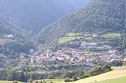
Mühlbach, South Tyrol
| Mühlbach | |
|---|---|
| Comune | |
| Marktgemeinde Mühlbach Comune di Rio di Pusteria |
|
 |
|
| Location of Mühlbach in Italy | |
| Coordinates: 46°48′N 11°40′E / 46.800°N 11.667°ECoordinates: 46°48′N 11°40′E / 46.800°N 11.667°E | |
| Country | Italy |
| Region | Trentino-Alto Adige/Südtirol |
| Province / Metropolitan city | South Tyrol (BZ) |
| Frazioni | Maranzen (Maranza), Spinges (Spinga), Vals (Valles) |
| Government | |
| • Mayor | Christoph Prugger |
| Area | |
| • Total | 84.1 km2 (32.5 sq mi) |
| Population (Nov. 2010) | |
| • Total | 2,955 |
| • Density | 35/km2 (91/sq mi) |
| Demonym(s) | German: Mühlbacher Italian: di Rio Pusteria |
| Time zone | CET (UTC+1) |
| • Summer (DST) | CEST (UTC+2) |
| Postal code | 39037 |
| Dialing code | 0472 |
| Website | Official website |
Mühlbach (German pronunciation: [ˈmyˑlbax]; Italian: Rio di Pusteria [ˈriːo di pusteˈriːa]) is a comune (municipality) in South Tyrol in northern Italy, located about 40 kilometres (25 mi) northeast of Bolzano.
As of 30 November 2010, it had a population of 2,955 and an area of 84.1 square kilometres (32.5 sq mi).
The municipality of Mühlbach contains the frazioni (subdivisions, mainly villages and hamlets) Meransen (Maranza), Spinges (Spinga), Vals (Valles).
Mühlbach borders the following municipalities: Freienfeld, Franzensfeste, Natz-Schabs, Rodeneck, Pfitsch, and Vintl.
The emblem is crossed diagonally by an argent wavy stream on vert; at the top a water wheel and an argent donkey at bottom. The water wheel symbolizes the water mill once numerous in the area for the grinding; the donkey represents the pack animals used for the transport. The emblem was adopted in 1971.
According to the 2011 census, 95.34% of the population speak German, 3.93% Italian and 0.73% Ladin as first language.
...
Wikipedia

