Lyonshall
| Lyonshall | |
|---|---|
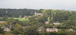
 View of Lyonshall village from the south |
|
| Lyonshall shown within Herefordshire | |
| Population | 757 (2011) |
| OS grid reference | SO3355 |
| Unitary authority | |
| Shire county | |
| Ceremonial county | |
| Region | |
| Country | England |
| Sovereign state | United Kingdom |
| Post town | KINGTON |
| Postcode district | HR5 |
| Dialling code | 01544 |
| Police | West Mercia |
| Fire | Hereford and Worcester |
| Ambulance | West Midlands |
| EU Parliament | West Midlands |
| UK Parliament | |
Lyonshall (English pronunciation: /ˈlaɪənzhɔːl/) is a historic village and civil parish in Herefordshire, England. According to the 2001 census it had a population of 750 increasing to 757 at the 2011 Census.
Lyonshall is a parish in the northwest corner of the county of Herefordshire, England. It is near to the border with Wales and has significant stretches of Offa's Dyke running through it. The northern boundary of the parish is marked by the River Arrow. Lyonshall Parish covers 5,000 acres (2,000 hectares) and is on the Black and White Village Trail. The population of 750 people live in 280 households spread across the parish and centred in the village. The town of Kington is 3 miles (4.8 km) to the west of Lyonshall.
Lyonshall was listed under the name Lenehalle the Domesday Book of 1086. The entry reads:
'LYONSHALL. Walter holds from him . Thorkell held from Earl Harold . 5 hides which pay tax. In Lordship 2 ploughs; 3 villagers, 11 smallholders and 3 riding men with 5 ploughs. 5 slaves, male and female. From some men settled there 110d are given for as long as they wish . Value before 1066, 60s; now 50s.'
Lyonshall is listed as being in the land of Roger of Lacy in Elsdon Hundred. Other villages in the same Hundred were Hopley's Green, Woonton, Eardisley and Letton. Also making an appearance in Domesday Book are the adjacent parishes of Kington, Titley and Rushock, all described as non-tax paying waste lands. To the east of Lyonshall lies Pembridge, which, like Lyonshall, is described as a reasonable sized manor.
...
Wikipedia

