Pembridge
| Pembridge | |
|---|---|
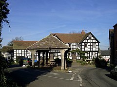
 Market Place, with the open-sided Market Hall in the foreground and the New Inn beyond |
|
| Pembridge shown within Herefordshire | |
| Population | 1,056 (2011 Census) |
| OS grid reference | SO39581 |
| Civil parish |
|
| Unitary authority | |
| Ceremonial county | |
| Region | |
| Country | England |
| Sovereign state | United Kingdom |
| Post town | Hereford |
| Postcode district | HR6 |
| Dialling code | 01544 |
| Police | West Mercia |
| Fire | Hereford and Worcester |
| Ambulance | West Midlands |
| EU Parliament | West Midlands |
| UK Parliament | |
| Website | Pembridge Parish Council |
Pembridge is a village and civil parish in Arrow valley in Herefordshire, England. The village is on the A44 road about 6 miles (10 km) east of Kington and 6 1⁄2 miles (10.5 km) west of Leominster. The civil parish includes the hamlets of Bearwood, Lower Bearwood, Lower Broxwood, Marston, Moorcot and Weston. The 2011 Census recorded the parish population as 1,056.
Pembridge is the major part of the electoral ward of Pembridge and Lyonshall with Titley. The 2011 Census recorded the ward's population as 3,124.
The toponym "Pembridge" may be derived from the Welsh Pen-y-Bont, anglicised to its current spelling.
The sandstone bridge over the river Arrow was granted Grade II listed status in June 1987, giving it protection from unauthorised alteration or demolition.
The oldest parts of St Mary's Church of England parish church are 12th-century, and the font and parts of the chancel are 13th-century. Most of the church has been dated c1320-60. Most spectacular are the arcades with circular cinquefoiled clerestory window. It is a cruciform church with 14th-century transepts and a vaulted north porch. There was a rood stair turret in the chancel with a pinnacle cover.
...
Wikipedia

