Lund, Nevada
| Lund, Nevada | |
|---|---|
| Census-designated place | |

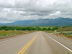
Lund from northbound Nevada State Route 318
|
|
| Location within the state of Nevada | |
| Coordinates: 38°51′22″N 115°0′22″W / 38.85611°N 115.00611°WCoordinates: 38°51′22″N 115°0′22″W / 38.85611°N 115.00611°W | |
| Country | United States |
| State | Nevada |
| County | White Pine |
| Area | |
| • Total | 1.7 sq mi (4.4 km2) |
| • Land | 1.7 sq mi (4.4 km2) |
| • Water | 0 sq mi (0 km2) |
| Elevation | 5,580 ft (1,700 m) |
| Population (2010) | |
| • Total | 282 |
| • Density | 170/sq mi (64/km2) |
| Time zone | Pacific (PST) (UTC-8) |
| • Summer (DST) | PDT (UTC-7) |
| ZIP codes | 89317 |
| Area code(s) | 775 |
| FIPS code | 32-43400 |
| GNIS feature ID | 0845548 |
Lund is a small town and census-designated place in White Pine County, Nevada, United States. Lund was named for Anthon H. Lund. Lund was settled in 1898 on land that the United States government had given The Church of Jesus Christ of Latter-day Saints (Mormons) in lieu of land that had been confiscated under the Edmunds–Tucker Act. The first settlers were Mormons, and the LDS Church still has a ward in Lund. The population of Lund as of 2010 was 282.
...
Wikipedia

