Lumberton, TX
| Lumberton, Texas | |
|---|---|
| City | |
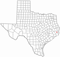
 Location of Lumberton, Texas |
|
 |
|
| Coordinates: 30°15′50″N 94°12′7″W / 30.26389°N 94.20194°WCoordinates: 30°15′50″N 94°12′7″W / 30.26389°N 94.20194°W | |
| Country | United States |
| State | Texas |
| County | Hardin |
| Area | |
| • Total | 13.4 sq mi (34.7 km2) |
| • Land | 13.3 sq mi (34.4 km2) |
| • Water | 0.1 sq mi (0.3 km2) |
| Elevation | 59 ft (18 m) |
| Population (2010) | |
| • Total | 11,943 |
| • Density | 898/sq mi (346.9/km2) |
| Time zone | Central (CST) (UTC-6) |
| • Summer (DST) | CDT (UTC-5) |
| ZIP code | 77657 |
| Area code(s) | 409 |
| FIPS code | 48-45120 |
| GNIS feature ID | 1340738 |
| Website | cityoflumberton |
Lumberton is a city in Hardin County, Texas, United States. The population was 11,943 at the 2010 census, up from 8,731 at the 2000 census. Lumberton is the home of Village Creek State Park. The city is part of the Beaumont–Port Arthur metropolitan area.
Lumberton is located in southeastern Hardin County at 30°15′50″N 94°12′7″W / 30.26389°N 94.20194°W (30.263896, -94.201918). According to the United States Census Bureau, the city has a total area of 13.4 square miles (34.7 km2), of which 13.3 square miles (34.4 km2) are land and 0.1 square miles (0.3 km2), or 0.77%, are water. The eastern border of the city is Village Creek, a southeast-flowing tributary of the Neches River.
The Eastex Freeway (comprising US 69, 96, and US 287) runs north from Beaumont to the southern border of Lumberton, where it splits into two separate highways, both running north to south, with Highway 96 in the eastern portion of the city and Highways 69 and 287 in the western portion. The two highways house the majority of the commercial development on the city. US 96 leads north-northeast 7 miles (11 km) to Silsbee, while Highway 69/287 leads northwest 11 miles (18 km) to Kountze, the Hardin County seat. Beaumont is 12 miles (19 km) to the south.
...
Wikipedia
