Ludiano
| Ludiano | ||
|---|---|---|
| Former municipality of Switzerland | ||
|
||
| Coordinates: 46°25′N 8°58′E / 46.417°N 8.967°ECoordinates: 46°25′N 8°58′E / 46.417°N 8.967°E | ||
| Country | Switzerland | |
| Canton | Ticino | |
| District | Blenio | |
| Area | ||
| • Total | 6.2 km2 (2.4 sq mi) | |
| Elevation | 477 m (1,565 ft) | |
| Population (December 2004) | ||
| • Total | 346 | |
| • Density | 56/km2 (140/sq mi) | |
| Postal code | 6721 | |
| SFOS number | 5040 | |
| Surrounded by | Acquarossa, Malvaglia, Semione, Sobrio | |
| Website | SFSO statistics |
|
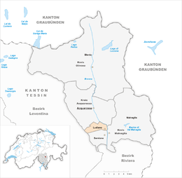
Ludiano is a former municipality in the district of Blenio in the canton of Ticino in Switzerland. Since 15 March 2011, it is part of the municipality Serravalle.
In 1926 a grave was discovered which contained Iron Age grave offerings. The modern municipality of Ludiano is first mentioned in 1211 as Luguilano. It was mentioned as a local center for surrounding farmhouses and villages in 1351.
The parish church of S. Secondo is first mentioned in 1293. It was rebuilt in 1779-82, though the older romanesque clock tower was retained.
In the past, the main sources of income were crops, livestock and vineyards. This income was supplemented by money sent back to the village by emigrants to other European countries. After the emigration-related decline in the mid-19th Century, the number of inhabitants has increased in the last decades of the 20th Century and has led to numerous new homes. In 2000 about half the jobs in the village were in manufacturing and the services sector accounted for about a fifth of the jobs. Two thirds of the working population earned their livelihood outside the community.
Ludiano has an area, as of 1997[update], of 6.19 square kilometers (2.39 sq mi). Of this area, 0.53 km2 (0.20 sq mi) or 8.6% is used for agricultural purposes, while 4.81 km2 (1.86 sq mi) or 77.7% is forested. Of the rest of the land, 0.25 km2 (0.097 sq mi) or 4.0% is settled (buildings or roads), 0.07 km2 (17 acres) or 1.1% is either rivers or lakes and 0.39 km2 (0.15 sq mi) or 6.3% is unproductive land.
Of the built up area, housing and buildings made up 2.9% and transportation infrastructure made up 1.0%. Out of the forested land, 75.1% of the total land area is heavily forested and 2.6% is covered with orchards or small clusters of trees. Of the agricultural land, 4.0% is used for growing crops, while 1.6% is used for orchards or vine crops and 2.9% is used for alpine pastures. All the water in the municipality is flowing water. Of the unproductive areas, 2.3% is unproductive vegetation and 4.0% is too rocky for vegetation.
...
Wikipedia


