Luba Crater Scientific Reserve
| Luba Crater Scientific Reserve | |
|---|---|

Forest near the village of San Antonio de Ureca, in the south of the reserve
|
|
| Coordinates | 3°21′12″N 8°30′47″E / 3.353377°N 8.513031°ECoordinates: 3°21′12″N 8°30′47″E / 3.353377°N 8.513031°E |
| Area | 51,000 hectares (130,000 acres) |
| Created | 2000 |
The Luba Crater Scientific Reserve (Spanish: Reserve Científica de la Caldera de Luba) is a protected area of 51,000 hectares (130,000 acres) on the volcanic island of Bioko (formerly called Fernando Pó), a part of Equatorial Guinea. The dense rainforest is rich in plant and animal species including a high population of primates, some endemic to the reserve. Much of the reserve consists of pristine forest. However, the primate population is under threat due to growing demand for bushmeat coupled with lack of enforcement of the ban on hunting in the reserve.
The Luba Crater Scientific Reserve is in the island of Bioko, which is part of the small country of Equatorial Guinea. Before the country gained independence from Spain in 1968 the main cash crop was cocoa. Since then agriculture has been neglected and many of the cocoa plantations have returned to the forest. Until recently a poor country, exploitation of large offshore reserves of oil and gas has dramatically increased the gross domestic product. However, the government is plagued by corruption and mismanagement, and distribution of wealth is unequal. Many people still depend on subsistence agriculture.
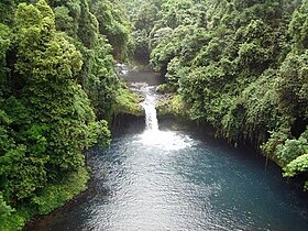
Bioko is on the African continental shelf and was probably connected to the mainland until the last ice age ended. It is part of the Cameroon line, a string of volcano-capped swells that extends for almost 1,000 kilometres (620 mi) from the island of Pagalu in the southwest through to Oku on the mainland in the northeast. Bioko is rugged, made up of two volcanic massifs. The Caldera de Luba is the highest point of the southern massif at 2,261 metres (7,418 ft). The shield volcano, formerly known as San Carlos, has been active in the last 2,000 years. Its geology is not well known. The crater has walls more than 1,000 metres (3,300 ft) high and a diameter of 5 kilometres (3.1 mi). The landscape is dramatic, including waterfalls cascading down the mountain slopes and black sand beaches along the shores.
Prevailing humid winds give the mountain an exceptionally wet climate. Up to 10,000 millimetres (390 in) of rain may fall in one year. Temperatures in the lower regions range from 17 °C (63 °F) to 34 °C (93 °F)
The forests in the reserve have been largely untouched, particularly on the wetter southern slopes of the mountain. At the lower levels, below 700 metres (2,300 ft), the reserve is covered by closed rain forest rich in species of vegetation. Above this, up to 2,000 metres (6,600 ft) in elevation, there is montane forest with many creepers and epiphytes growing on the trees. The reserve also contains Araliaceae and Arecaceae (palm tree) forests. The original lowland rain forests typically have tall trees of up to 50 metres (160 ft) emerging from a canopy of around 30 metres (98 ft). The understory is relatively sparse. The most dominant trees are in the Ficus genus. Other trees belongs to the Chrysophyllum, Milicia, Ricinodendron and Euphorbiaceae genera.
...
Wikipedia


