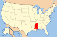
Lowndes County, Mississippi
| Lowndes County, Mississippi | |
|---|---|
 Location in the U.S. state of Mississippi |
|
 Mississippi's location in the U.S. |
|
| Founded | 1830 |
| Named for | William Jones Lowndes |
| Seat | Columbus |
| Largest city | Columbus |
| Area | |
| • Total | 516 sq mi (1,336 km2) |
| • Land | 506 sq mi (1,311 km2) |
| • Water | 11 sq mi (28 km2), 2.1% |
| Population | |
| • (2010) | 59,779 |
| • Density | 118/sq mi (46/km²) |
| Congressional district | 1st |
| Time zone | Central: UTC-6/-5 |
| Website | lowndescountyms |
Lowndes County is a county located in the U.S. state of Mississippi. As of the 2010 census, the population was 59,779. Its county seat is Columbus. The county is named for U.S. Congressman William Jones Lowndes.
Lowndes County comprises the Columbus, MS Micropolitan Statistical Area. Since the late 20th century, it has been designated as one of three counties in the Golden Triangle region of the state.
According to the U.S. Census Bureau, the county has a total area of 516 square miles (1,340 km2), of which 506 square miles (1,310 km2) is land and 11 square miles (28 km2) (2.1%) is water.
As of the 2010 United States Census, there were 59,779 people residing in the county. 54.0% were White, 43.5% Black or African American, 0.7% Asian, 0.2% Native American, 0.1% Pacific Islander, 0.6% of some other race and 1.1% of two or more races. 1.5% were Hispanic or Latino (of any race).
As of the census of 2000, there were 61,586 people, 22,849 households, and 16,405 families residing in the county. The population density was 123 people per square mile (47/km²). There were 25,104 housing units at an average density of 50 per square mile (19/km²). The racial makeup of the county was 56.47% White, 41.56% Black or African American, 0.17% Native American, 0.54% Asian, 0.03% Pacific Islander, 0.39% from other races, and 0.85% from two or more races. 1.11% of the population were Hispanic or Latino of any race.
...
Wikipedia
