Loveland, Ohio
| Loveland, Ohio | |||
|---|---|---|---|
| City | |||
| City of Loveland, Ohio | |||
|
Historic Downtown Loveland
|
|||
|
|||
| Nickname(s): Sweetheart of Ohio, | |||
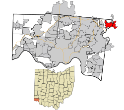
 Location in Hamilton County and the state of Ohio. |
|||
| Coordinates: 39°16′8″N 84°16′14″W / 39.26889°N 84.27056°WCoordinates: 39°16′8″N 84°16′14″W / 39.26889°N 84.27056°W | |||
| Country | United States | ||
| State | Ohio | ||
| Counties | Hamilton, Clermont, Warren | ||
| Settled | 1795 | ||
| Incorporated (village) | May 1876 | ||
| Chartered (city) | July 25, 1961 | ||
| Founded by | Col. Thomas Paxton | ||
| Named for | James Loveland | ||
| Government | |||
| • Type | Council-manager | ||
| • Mayor | Mark Fitzgerald (R) | ||
| • City manager | Dave Kennedy | ||
| Area | |||
| • Total | 5.00 sq mi (12.95 km2) | ||
| • Land | 4.93 sq mi (12.77 km2) | ||
| • Water | 0.07 sq mi (0.18 km2) 1.40% | ||
| Elevation | 597 ft (182 m) | ||
| Population (2010) | |||
| • Total | 12,081 | ||
| • Estimate (2013) | 12,326 | ||
| • Density | 2,450.5/sq mi (946.1/km2) | ||
| Time zone | EST (UTC-5) | ||
| • Summer (DST) | EDT (UTC-4) | ||
| ZIP codes | 45140, 45249 | ||
| Area code(s) | 513 | ||
| FIPS code | 39-45108 | ||
| GNIS feature ID | 1085672 | ||
| LOCODE | US XHT | ||
| Website | City of Loveland | ||
Loveland (/ˈlʌvlᵻn/ LUV-lənd) is a city in Hamilton, Clermont, and Warren counties in the southwestern part of the U.S. state of Ohio. Considered part of the Greater Cincinnati area, Loveland is located near exit 52 off Interstate 275, about 15 miles (24 km) northeast of the Cincinnati city limits. It borders Symmes, Miami and Hamilton Townships and straddles the Little Miami River. The population was 12,081 at the 2010 census and was estimated at 12,326 in 2013. Once a busy railroad town, Loveland is now a major stop along the Little Miami Scenic Trail.
According to the United States Census Bureau, the city has a total area of 5.00 square miles (12.95 km2), of which 4.93 square miles (12.77 km2) is land and 0.07 square miles (0.18 km2) is water. The city is situated at an elevation of 597 ft (182 m) above sea level.
...
Wikipedia


