Lovön
| Lovön | |
| Island | |
|
Drottningholm Palace on Lovön
|
|
| Country | Sweden |
|---|---|
| County | |
| Municipality | Ekerö |
| Location | Mälaren |
| - coordinates | 59°20′N 17°50′E / 59.333°N 17.833°ECoordinates: 59°20′N 17°50′E / 59.333°N 17.833°E |
| Area | 23.22 km2 (9 sq mi) |
|
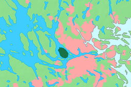
The Island is highlighted in dark green, Stockholm urban area in pink.
|
|
Lovön is an island located in the Swedish Lake Mälaren in Ekerö Municipality of . It was a municipality of its own until 1952, when it was joined with Ekerö Municipality. Lovön's greatest attraction is Drottningholm Palace and its many public gardens, which were built on the island in 1580.
There is much known about the history of this rather small island. Owing to its status today as a World Heritage Site, much research has gone into its history. It is estimated that Lovön has been inhabited since around the 25th century BC.
Traces of hunting and fishing camps dated as old as 2500 B.C. have been found by archaeologists on Lovön. Harpoons made of bone, stone tools, ceramic bowls, and remains of huts are some artifacts that have been located and researched. It is also believed that these camps were seasonal quarters rather than year-round habitations. The island was at this point a set of broken-up smaller islands, since the water level in Lake Mälaren was significantly higher than it is today.
During the Nordic Bronze Age permanent settlement began. As to the water level dropped off, more land was exposed, and the smaller islands were shaped into a coherent landmass. New wetlands were created in the low-lying areas, moist and fertile. Archaeological studies show a large amount of juniper and grass pollen — a sign that much of Lovön was open land for cattle-grazing. Archaeologists have found smaller living quarters around the spot where the church is located today. 30 or so stone burial mounds have been found scattered throughout the island from this period. From the bone materials found in these burial mounds it has established that only men were put in burial mounds, and only one person per generation received this type of burial, suggesting that the buried men were chieftains. Towards the end of the Bronze Age, pollen counts indicate abundant spruce trees growing in the open fields.
During the Iron Age the waters of Mälaren receded again and new land masses were created, causing an increase in the population. Farming families, tilling the fertile lower lands, became the norm. Each family would typically have their own set of fields and a family graveyard, placed on infertile lands. Consequently, many of the graves have been untouched until modern times.
...
Wikipedia


