Louis Hippolyte Lafontaine Tunnel
| Louis-Hippolyte Lafontaine Bridge–Tunnel (bridge part) | |||||||||||||||||||||||||||
|---|---|---|---|---|---|---|---|---|---|---|---|---|---|---|---|---|---|---|---|---|---|---|---|---|---|---|---|
 |
|||||||||||||||||||||||||||
| Carries | Autoroute 25 | ||||||||||||||||||||||||||
| Crosses | Saint Lawrence River | ||||||||||||||||||||||||||
| Named for | |||||||||||||||||||||||||||
|
|||||||||||||||||||||||||||

Inside the tunnel. One of the three lanes is shown to be reversible.
|
|||||||||||||||||||||
| Overview | |||||||||||||||||||||
|---|---|---|---|---|---|---|---|---|---|---|---|---|---|---|---|---|---|---|---|---|---|
| Route | Autoroute 25 | ||||||||||||||||||||
| Crosses | Saint Lawrence River | ||||||||||||||||||||
| Start | Montreal Island | ||||||||||||||||||||
| End | |||||||||||||||||||||
|
|||||||||||||||||||||
Île Charron (Îles de Boucherville)
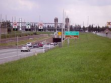
The Louis-Hippolyte Lafontaine Bridge–Tunnel (Pont-Tunnel Louis-Hippolyte-La Fontaine) is a Canadian highway bridge–tunnel running over and beneath the Saint Lawrence River. It connects the Island of Montreal with the south shore of the river at Longueuil, Quebec.
Construction began in 1963 and it opened on March 11, 1967. Named for the respected Lower Canada political reformer Louis-Hippolyte Lafontaine, the Lafontaine Tunnel is an immersed tube structure, measuring 1,391 m (4,563.6 ft) long. It carries the Autoroute 25 expressway and passes beneath the main shipping channel in the Saint. Lawrence River immediately downstream from the Saint Lawrence Seaway. It surfaces on Île Charron (Îles de Boucherville at entrance/exit #1 of Autoroute 25), then continues by bridge to Longueuil.
Each section weighs 32,000 t (31,000 long tons; 35,000 short tons), is 110 metres (360 ft) long, 37 metres (121 ft) wide and rises to a height of 8 metres (26 ft). In total, the bridge–tunnel is 1.8 kilometres (1.1 mi) long. It is estimated that 44 million vehicles drive through it per year, or 120,000 per day. The tunnel was built with sections prefabricated in dry dock and then sunk in the river, 24 metres (79 ft) below the surface of the water. It is one of the largest prestressed concrete structures in the world.
...
Wikipedia
