Loogootee, Indiana
| Loogootee, Indiana | |
|---|---|
| City | |

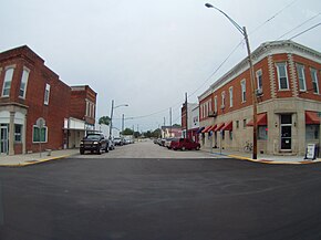
Looking down West Main Street from U.S. 231
|
|
 Location in the state of Indiana |
|
| Coordinates: 38°40′35″N 86°54′53″W / 38.67639°N 86.91472°WCoordinates: 38°40′35″N 86°54′53″W / 38.67639°N 86.91472°W | |
| Country | United States |
| State | Indiana |
| County | Martin |
| Township | Perry |
| Government | |
| • Mayor | Noel D Harty (D) |
| Area | |
| • Total | 1.57 sq mi (4.07 km2) |
| • Land | 1.57 sq mi (4.07 km2) |
| • Water | 0 sq mi (0 km2) 0% |
| Elevation | 538 ft (164 m) |
| Population (2010) | |
| • Total | 2,751 |
| • Estimate (2012) | 2,726 |
| • Density | 1,752.2/sq mi (676.5/km2) |
| Time zone | EST (UTC-5) |
| • Summer (DST) | EDT (UTC-4) |
| ZIP code | 47553 |
| Area code(s) | 812 |
| FIPS code | 18-44910 |
| GNIS feature ID | 0438296 |
Loogootee is a city in Perry Township, Martin County, Indiana, United States. The population was 2,751 at the 2010 census.
Hoosiers from the area pronounce the name of the town /ləˈɡoʊtiː/. Several etymologies of the place name have been proposed. One would make it an Anglicization of the French name Le Gaultier. [1] Another would make it a compound word honoring Thomas Lowe, engineer of the first train through the town; and Thomas Nesbe Gootee (1797-1870), owner of the land where the town was built. [2] However, the latter origin does not explain the presence of an identically named unincorporated village in Lone Grove Township, Fayette County, Illinois. Since Loogootee, Illinois is due west of Loogootee, Indiana, there is a possibility that pioneers named their town in Illinois after the town they came from in Indiana.
Loogootee was established in 1853 when it was certain that a new railroad line would be extended to that point.
Loogootee is located at 38°40′35″N 86°54′53″W / 38.676518°N 86.914794°W.
...
Wikipedia
