Long Hill Township, New Jersey
| Long Hill Township, New Jersey | |
|---|---|
| Township | |
| Township of Long Hill | |

Millington Train Station, one of three train stations in Long Hill Township.
|
|
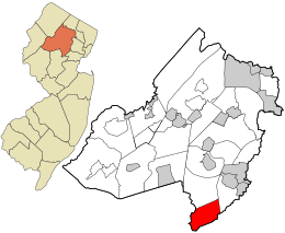
 Location in Morris County and the state of New Jersey. |
|
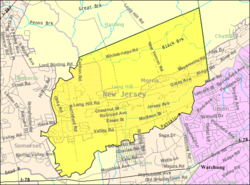
 Census Bureau map of Long Hill Township, New Jersey |
|
| Coordinates: 40°41′05″N 74°29′31″W / 40.684827°N 74.492069°WCoordinates: 40°41′05″N 74°29′31″W / 40.684827°N 74.492069°W | |
| Country |
|
| State |
|
| County | Morris |
| Incorporated | March 23, 1866 (as Passaic Township) |
| Renamed | November 3, 1992 (as Long Hill Township) |
| Government | |
| • Type | Township |
| • Body | Township Committee |
| • Mayor | Bruce Meringolo (R, term ends December 31, 2016) |
| • Administrator | Neil Henry |
| • Clerk | Cathy Reese |
| Area | |
| • Total | 12.136 sq mi (31.432 km2) |
| • Land | 11.851 sq mi (30.693 km2) |
| • Water | 0.285 sq mi (0.739 km2) 2.35% |
| Area rank | 191st of 566 in state 15th of 39 in county |
| Elevation | 325 ft (99 m) |
| Population (2010 Census) | |
| • Total | 8,702 |
| • Estimate (2015) | 8,779 |
| • Rank | 263rd of 566 in state 22nd of 39 in county |
| • Density | 734.3/sq mi (283.5/km2) |
| • Density rank | 410th of 566 in state 31st of 39 in county |
| Time zone | Eastern (EST) (UTC−5) |
| • Summer (DST) | Eastern (EDT) (UTC−4) |
| ZIP codes | 07933 – Gillette 07946 – Millington 07980 – Stirling |
| Area code | 908 |
| FIPS code | 3402741362 |
| GNIS feature ID | 0882196 |
| Website | longhillnj |
Long Hill Township is a township in Morris County, New Jersey, United States. As of the 2010 United States Census, the township's population was 8,702, reflecting a decline of 75 (-0.9%) from the 8,777 counted in the 2000 Census, which had in turn increased by 951 (+12.2%) from the 7,826 counted in the 1990 Census.
Long Hill Township was incorporated as Passaic Township on March 23, 1866. On September 1, 1922, part of what was then Passaic Township was taken to form Harding Township. On November 3, 1992, by a 1,901-1,821 margin, the voters elected to change the name of the municipality to Long Hill Township, a change largely driven by the desire to avoid confusion with the City of Passaic, some 22 miles (35 km) away.
According to the United States Census Bureau, the township had a total area of 12.136 square miles (31.432 km2), including 11.851 square miles (30.693 km2) of land and 0.285 square miles (0.739 km2) of water (2.35%).
Unincorporated communities, localities and place names located partially or completely within the township include Gillette, Millington, and Stirling, and the hamlet of Meyersville. Homestead Park is a subdivision that was first developed in the 1920s.
The township is located in the most southern part of Morris County. It is bounded by the Passaic River on the south and west and by the Great Swamp National Wildlife Refuge on the north. It borders both Union and Somerset counties.
...
Wikipedia
